
Topografische kaart Ellsworth
Interactieve kaart
Klik op de kaart om de hoogte weer te geven.
Over deze kaart
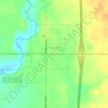
Naam: Topografische kaart Ellsworth, hoogte, reliëf.
Locatie: Ellsworth, Hamilton County, Iowa, 50075, United States (42.30324 -93.60101 42.31782 -93.56999)
Gemiddelde hoogte: 332 m
Minimale hoogte: 315 m
Maximale hoogte: 349 m
Andere topografische kaarten
Klik op een kaart om zijn topografie, zijn hoogte en zijn reliëf te bekijken.
Randall
United States > Iowa > Hamilton County
Randall, Hamilton County, Iowa, 50231, United States
Gemiddelde hoogte: 313 m
Stratford
United States > Iowa > Hamilton County
Stratford, Hamilton County, Iowa, United States
Gemiddelde hoogte: 336 m
Jewell Junction
United States > Iowa > Hamilton County
Jewell Junction, Hamilton County, Iowa, United States
Gemiddelde hoogte: 324 m
Kamrar
United States > Iowa > Hamilton County
Kamrar, Hamilton County, Iowa, United States
Gemiddelde hoogte: 337 m
Blairsburg
United States > Iowa > Hamilton County
Blairsburg, Hamilton County, Iowa, United States
Gemiddelde hoogte: 373 m
Williams
United States > Iowa > Hamilton County
Williams, Hamilton County, Iowa, United States
Gemiddelde hoogte: 365 m
Stanhope
United States > Iowa > Hamilton County
Stanhope, Hamilton County, Iowa, United States
Gemiddelde hoogte: 337 m
Webster City
United States > Iowa > Hamilton County
Webster City, Hamilton County, Iowa, 50595, United States
Gemiddelde hoogte: 328 m