
Topografische kaart Emerson
Interactieve kaart
Klik op de kaart om de hoogte weer te geven.
Over deze kaart
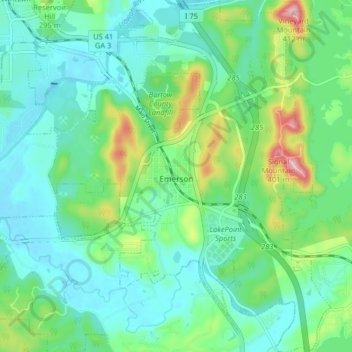
Naam: Topografische kaart Emerson, hoogte, reliëf.
Locatie: Emerson, Bartow County, Georgia, 30137, United States (34.09402 -84.78494 34.16097 -84.71986)
Gemiddelde hoogte: 254 m
Minimale hoogte: 205 m
Maximale hoogte: 402 m
Andere topografische kaarten
Klik op een kaart om zijn topografie, zijn hoogte en zijn reliëf te bekijken.
Cartersville
United States > Georgia > Bartow County
Cartersville, Bartow County, Georgia, 30120, United States
Gemiddelde hoogte: 260 m
Rydal
United States > Georgia > Bartow County
Rydal, Bartow County, Georgia, 30171, United States
Gemiddelde hoogte: 273 m
Taylorsville
United States > Georgia > Bartow County
Taylorsville, Bartow County, Georgia, United States
Gemiddelde hoogte: 227 m
White
United States > Georgia > Bartow County
White, Bartow County, Georgia, United States
Gemiddelde hoogte: 271 m
Euharlee
United States > Georgia > Bartow County
Euharlee, Bartow County, Georgia, United States
Gemiddelde hoogte: 215 m
Red Top Mountain State Park
United States > Georgia > Bartow County
Red Top Mountain State Park, Bartow County, Georgia, United States
Gemiddelde hoogte: 276 m
Adairsville
United States > Georgia > Bartow County
Adairsville, Bartow County, Georgia, 30103, United States
Gemiddelde hoogte: 254 m
Weiss Lake
United States > Georgia > Bartow County > Cartersville
Weiss Lake, Cartersville, Bartow County, Georgia, United States
Gemiddelde hoogte: 276 m
Emerson
United States > Georgia > Bartow County > Emerson
Emerson, Bartow County, Georgia, 30137, United States
Gemiddelde hoogte: 266 m
Kingston
United States > Georgia > Bartow County
Kingston, Bartow County, Georgia, United States
Gemiddelde hoogte: 223 m