
Topografische kaart Rhinecliff
Interactieve kaart
Klik op de kaart om de hoogte weer te geven.
Rhinecliff
The hamlet is demarcated by large agricultural and wooded area to the north, east, and south, and bounded by the Hudson River on the west. Steep topography, formed by contorted slate ridges and valleys, define the site-specific and seemingly random orientation of the small, frame nineteenth-century houses and winding narrow roads. The hamlet had a mid-nineteenth century building boom, but its boundaries and building density have changed very little over the last one hundred years.
Over deze kaart
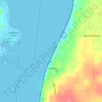
Naam: Topografische kaart Rhinecliff, hoogte, reliëf.
Gemiddelde hoogte: 19 m
Minimale hoogte: -9 m
Maximale hoogte: 73 m
Andere topografische kaarten
Klik op een kaart om zijn topografie, zijn hoogte en zijn reliëf te bekijken.
Drayton Grant Park at Burger Hill
United States > New York > Dutchess County > Town of Rhinebeck
Gemiddelde hoogte: 102 m