
Topografische kaart Frontier Town
Interactieve kaart
Klik op de kaart om de hoogte weer te geven.
Over deze kaart
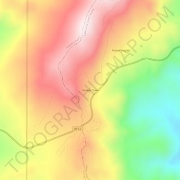
Naam: Topografische kaart Frontier Town, hoogte, reliëf.
Gemiddelde hoogte: 1.870 m
Minimale hoogte: 1.519 m
Maximale hoogte: 2.157 m
Andere topografische kaarten
Klik op een kaart om zijn topografie, zijn hoogte en zijn reliëf te bekijken.
Helena
United States > Montana > Lewis and Clark County
Helena, Lewis and Clark County, Montana, United States
Gemiddelde hoogte: 1.296 m
Craig
United States > Montana > Lewis and Clark County
Craig, Lewis and Clark County, Montana, United States
Gemiddelde hoogte: 1.096 m
Augusta
United States > Montana > Lewis and Clark County > Augusta
Augusta, Lewis and Clark County, Montana, 59410, United States
Gemiddelde hoogte: 1.246 m
Broadwater
United States > Montana > Lewis and Clark County
Broadwater, Lewis and Clark County, Montana, 59636, United States
Gemiddelde hoogte: 1.284 m
York
United States > Montana > Lewis and Clark County
York, Lewis and Clark County, Montana, United States
Gemiddelde hoogte: 1.348 m
Sugar Loaf
United States > Montana > Lewis and Clark County
Sugar Loaf, Lewis and Clark County, Montana, United States
Gemiddelde hoogte: 1.881 m
Devils Tower
United States > Montana > Lewis and Clark County
Devils Tower, Lewis and Clark County, Montana, United States
Gemiddelde hoogte: 1.373 m
Canyon Point
United States > Montana > Lewis and Clark County
Canyon Point, Lewis and Clark County, Montana, United States
Gemiddelde hoogte: 2.081 m
Mount Helena
United States > Montana > Lewis and Clark County > Helena
Mount Helena, Helena, Lewis and Clark County, Montana, 59601, United States
Gemiddelde hoogte: 1.388 m