
Topografische kaart Ahaura River
Interactieve kaart
Klik op de kaart om de hoogte weer te geven.
Over deze kaart
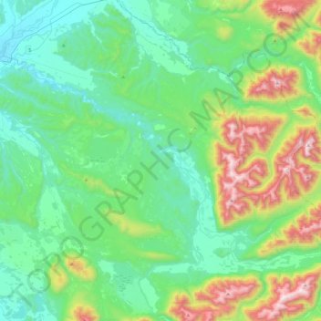
Naam: Topografische kaart Ahaura River, hoogte, reliëf.
Locatie: Ahaura River, Grey District, West Coast, 7843, New Zealand (-42.56351 171.52317 -42.34742 171.97023)
Gemiddelde hoogte: 386 m
Minimale hoogte: 47 m
Maximale hoogte: 1.459 m
Andere topografische kaarten
Klik op een kaart om zijn topografie, zijn hoogte en zijn reliëf te bekijken.
Greymouth
New Zealand > West Coast > Grey District
Greymouth, Grey District, West Coast, 7801, New Zealand
Gemiddelde hoogte: 40 m
Atarau
New Zealand > West Coast > Grey District
Atarau, Grey District, West Coast, 7843, New Zealand
Gemiddelde hoogte: 59 m
Taylorville
New Zealand > West Coast > Grey District
Taylorville, Grey District, West Coast, New Zealand
Gemiddelde hoogte: 125 m
Lake Brunner
New Zealand > West Coast > Grey District > Moana
Lake Brunner, Moana, Grey District, West Coast, New Zealand
Gemiddelde hoogte: 168 m
Ngahere
New Zealand > West Coast > Grey District > Ngahere
Ngahere, Grey District, West Coast, 7804, New Zealand
Gemiddelde hoogte: 49 m