
Topografische kaart Hardeeville
Interactieve kaart
Klik op de kaart om de hoogte weer te geven.
Over deze kaart
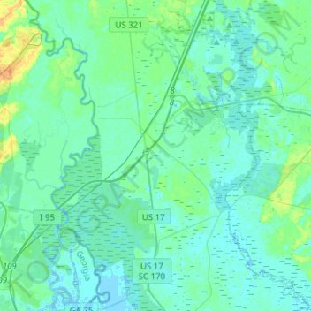
Naam: Topografische kaart Hardeeville, hoogte, reliëf.
Gemiddelde hoogte: 5 m
Minimale hoogte: -4 m
Maximale hoogte: 27 m
The city is located on the Atlantic coastal plain, with very few variations in elevation. The average elevation of the city is approximately 20 feet (6.1 m) above mean sea level. Most of Hardeeville is located within Jasper County, though a small portion of the city crosses into Beaufort County. Much of the city is bordered to the west by the Savannah National Wildlife Refuge, a large-scale nature preserve along the South Carolina and Georgia sides of the Savannah River.
Andere topografische kaarten
Klik op een kaart om zijn topografie, zijn hoogte en zijn reliëf te bekijken.
Ridgeland
United States > South Carolina > Jasper County
Ridgeland, Jasper County, South Carolina, United States
Gemiddelde hoogte: 15 m
Latitude Margaritaville
United States > South Carolina > Jasper County > Hardeeville
Latitude Margaritaville, Hardeeville, Jasper County, South Carolina, 29927, United States
Gemiddelde hoogte: 4 m