
Topografische kaart Tecopa
Interactieve kaart
Klik op de kaart om de hoogte weer te geven.
Over deze kaart
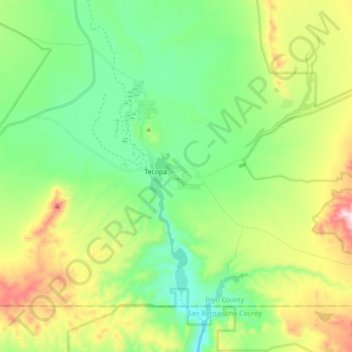
Naam: Topografische kaart Tecopa, hoogte, reliëf.
Locatie: Tecopa, Inyo County, California, United States (35.79330 -116.28677 35.89955 -116.10947)
Gemiddelde hoogte: 508 m
Minimale hoogte: 308 m
Maximale hoogte: 926 m
Tecopa (formerly Brownsville[4]) is a census-designated place (CDP) in the Mojave Desert, in Inyo County, California, United States. Tecopa is located 9 miles (14 km) south-southeast of Shoshone,[4] at an elevation of 1,339 feet (408 m).[3] The population was 150 at the 2010 census, up from 99 at the 2000 census.