Topografische kaart Lubenham
Interactieve kaart
Klik op de kaart om de hoogte weer te geven.
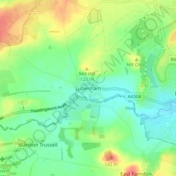
Over deze kaart
Andere topografische kaarten
Klik op een kaart om zijn topografie, zijn hoogte en zijn reliëf te bekijken.
Cranoe
United Kingdom > England > Leicestershire > Harborough District
Cranoe, Harborough District, Leicestershire, England, LE16 7SW, United Kingdom
Gemiddelde hoogte: 108 m
Great Easton
United Kingdom > England > Leicestershire > Harborough District > Great Easton
Great Easton, Harborough District, Leicestershire, England, LE16 8SL, United Kingdom
Gemiddelde hoogte: 72 m
Catthorpe
United Kingdom > England > Leicestershire > Harborough District > Catthorpe
Catthorpe, Harborough District, Leicestershire, England, LE17 6DD, United Kingdom
Gemiddelde hoogte: 113 m
Church Langton
United Kingdom > England > Leicestershire > Harborough District > Church Langton
Church Langton, Harborough District, Leicestershire, England, LE16 7FW, United Kingdom
Gemiddelde hoogte: 100 m
Eyebrook Reservoir
United Kingdom > England > Leicestershire > Harborough District > Stockerston
Eyebrook Reservoir, Stockerston, Harborough District, Leicestershire, East Midlands, England, United Kingdom
Gemiddelde hoogte: 85 m
Upper Bruntingthorpe
United Kingdom > England > Leicestershire > Harborough District > Walton > Upper Bruntingthorpe
Upper Bruntingthorpe, Bruntingthorpe, Walton, Harborough District, Leicestershire, England, LE17 5QP, United Kingdom
Gemiddelde hoogte: 143 m
Carlton Carlieu
United Kingdom > England > Leicestershire > Harborough District > Carlton Carlieu
Carlton Carlieu, Harborough District, Leicestershire, England, United Kingdom
Gemiddelde hoogte: 135 m
Ingarsby
United Kingdom > England > Leicestershire > Harborough District > Ingarsby
Ingarsby, Hungarton, Harborough District, Leicestershire, East Midlands, England, LE7 9JL, United Kingdom
Gemiddelde hoogte: 139 m
Blaston
United Kingdom > England > Leicestershire > Harborough District
Blaston, Harborough District, Leicestershire, England, LE16 8DE, United Kingdom
Gemiddelde hoogte: 112 m
North Kilworth
United Kingdom > England > Leicestershire > Harborough District
North Kilworth, Harborough District, Leicestershire, England, LE17 6HQ, United Kingdom
Gemiddelde hoogte: 142 m
Ashby Parva
United Kingdom > England > Leicestershire > Harborough District
Ashby Parva, Harborough District, Leicestershire, England, LE17 5HT, United Kingdom
Gemiddelde hoogte: 123 m
Dunton Bassett
United Kingdom > England > Leicestershire > Harborough District
Dunton Bassett, Harborough District, Leicestershire, England, LE17 5LL, United Kingdom
Gemiddelde hoogte: 117 m
Cotesbach
United Kingdom > England > Leicestershire > Harborough District
Cotesbach, Harborough District, Leicestershire, England, LE17 4HZ, United Kingdom
Gemiddelde hoogte: 122 m
Allexton
United Kingdom > England > Leicestershire > Harborough District
Allexton, Harborough District, Leicestershire, England, LE15 9AG, United Kingdom
Gemiddelde hoogte: 128 m
Gilmorton
United Kingdom > England > Leicestershire > Harborough District
Gilmorton, Harborough District, Leicestershire, England, LE17 5PA, United Kingdom
Gemiddelde hoogte: 138 m
Smeeton Westerby
United Kingdom > England > Leicestershire > Harborough District
Smeeton Westerby, Harborough District, Leicestershire, England, LE8 0RT, United Kingdom
Gemiddelde hoogte: 114 m