
Topografische kaart Ankeny
Interactieve kaart
Klik op de kaart om de hoogte weer te geven.
Over deze kaart
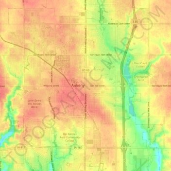
Naam: Topografische kaart Ankeny, hoogte, reliëf.
Locatie: Ankeny, Polk County, Iowa, 50023-3054, United States (41.69187 -93.64038 41.77187 -93.56038)
Gemiddelde hoogte: 289 m
Minimale hoogte: 255 m
Maximale hoogte: 307 m
Like most of Polk County, Ankeny exists at the bottom area of the Des Moines Lobe, a topographical landscape area, in an area known as the Bemis Advance. The Lobe was formed during the Wisconsin glaciation leaving significant deposits resulting in an area with low relief.