
Topografische kaart Sweetwater Creek State Park
Interactieve kaart
Klik op de kaart om de hoogte weer te geven.
Over deze kaart
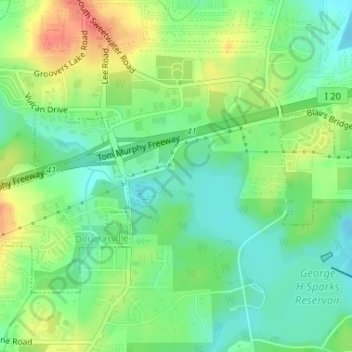
Naam: Topografische kaart Sweetwater Creek State Park, hoogte, reliëf.
Gemiddelde hoogte: 288 m
Minimale hoogte: 266 m
Maximale hoogte: 320 m
Andere topografische kaarten
Klik op een kaart om zijn topografie, zijn hoogte en zijn reliëf te bekijken.
Chapel Hill
United States > Georgia > Douglas County
Chapel Hill, Douglas County, Georgia, 30135, United States
Gemiddelde hoogte: 296 m
Winston
United States > Georgia > Douglas County
Winston, Douglas County, Georgia, 30187, United States
Gemiddelde hoogte: 340 m
Tyree
United States > Georgia > Douglas County
Tyree, Douglas County, Georgia, United States
Gemiddelde hoogte: 346 m
Douglasville
United States > Georgia > Douglas County
Douglasville, Douglas County, Georgia, 30133, United States
Gemiddelde hoogte: 310 m
Andy Mountain
United States > Georgia > Douglas County
Andy Mountain, Douglas County, Georgia, 30187, United States
Gemiddelde hoogte: 344 m
Lithia Springs
United States > Georgia > Douglas County
Lithia Springs, Douglas County, Georgia, 30122, United States
Gemiddelde hoogte: 295 m
Douglas Estates
United States > Georgia > Douglas County > Douglas Estates
Douglas Estates, Douglas County, Georgia, 30135, United States
Gemiddelde hoogte: 292 m