
Topografische kaart Oneida County
Interactieve kaart
Klik op de kaart om de hoogte weer te geven.
Over deze kaart
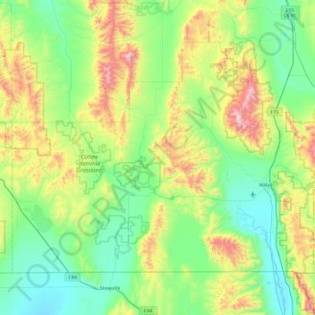
Naam: Topografische kaart Oneida County, hoogte, reliëf.
Locatie: Oneida County, Idaho, United States (41.99724 -113.00008 42.50306 -112.07027)
Gemiddelde hoogte: 1.678 m
Minimale hoogte: 1.325 m
Maximale hoogte: 2.747 m
Oxford Peak is the highest point in the county at 9,285 ft (2830.2 m) above sea level. Alternating valleys and ridges of mountains or hills typify the topography, with grassland and sagebrush covering most areas. The Curlew National Grassland lies within the county.
Andere topografische kaarten
Klik op een kaart om zijn topografie, zijn hoogte en zijn reliëf te bekijken.
Malad Summit
United States > Idaho > Oneida County
Malad Summit, Oneida County, Idaho, United States
Gemiddelde hoogte: 1.715 m