
Topografische kaart Fort Worth
Interactieve kaart
Klik op de kaart om de hoogte weer te geven.
Over deze kaart
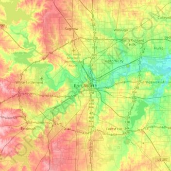
Naam: Topografische kaart Fort Worth, hoogte, reliëf.
Locatie: Fort Worth, Tarrant County, Texas, 76102, United States (32.59318 -97.49275 32.91318 -97.17275)
Gemiddelde hoogte: 202 m
Minimale hoogte: 139 m
Maximale hoogte: 279 m
Andere topografische kaarten
Klik op een kaart om zijn topografie, zijn hoogte en zijn reliëf te bekijken.
Summerfields/Chisholm Park
United States > Texas > Tarrant County > Fort Worth
Summerfields/Chisholm Park, Fort Worth, Tarrant County, Texas, United States
Gemiddelde hoogte: 203 m
Tarrant
United States > Texas > Tarrant County > Fort Worth
Tarrant, Fort Worth, Tarrant County, Texas, 76005, United States
Gemiddelde hoogte: 155 m
Melody Hills
United States > Texas > Tarrant County > Fort Worth
Melody Hills, Fort Worth, Tarrant County, Texas, 76161, United States
Gemiddelde hoogte: 191 m
Benbrook Lake
United States > Texas > Tarrant County > Fort Worth
Benbrook Lake, Fort Worth, Tarrant County, Texas, United States
Gemiddelde hoogte: 230 m
Rendon
United States > Texas > Tarrant County > Fort Worth
Rendon, Fort Worth, Tarrant County, Texas, United States
Gemiddelde hoogte: 221 m
Will Rogers Memorial Center
United States > Texas > Tarrant County > Fort Worth
Will Rogers Memorial Center, Fort Worth, Tarrant County, Texas, United States
Gemiddelde hoogte: 181 m
Magnolia Micro Park
United States > Texas > Tarrant County > Fort Worth
Magnolia Micro Park, Fort Worth, Tarrant County, Texas, United States
Gemiddelde hoogte: 195 m