
Topografische kaart Taylor
Klik op de kaart om de hoogte weer te geven.
Over deze kaart
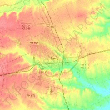
Naam: Topografische kaart Taylor, hoogte, reliëf.
Locatie: Taylor, Williamson County, Texas, 76574, United States (30.53011 -97.51248 30.62294 -97.36215)
Gemiddelde hoogte: 178 m
Minimale hoogte: 141 m
Maximale hoogte: 201 m
Andere topografische kaarten
Klik op een kaart om zijn topografie, zijn hoogte en zijn reliëf te bekijken.
Georgetown
United States > Texas > Williamson County > Georgetown
The city is located on the northeastern edge of Texas Hill Country. Portions of Georgetown are located on either side of the Balcones Escarpment, a fault line in which the areas roughly east of IH-35 are flat and characterized by having black, fertile soils of the Blackland Prairie, and the west side of the…
Gemiddelde hoogte: 228 m
Soil Conservation Service Site 12 Dam
United States > Texas > Williamson County > Type
Gemiddelde hoogte: 173 m
Soil Conservation Service Site 12 Dam
United States > Texas > Williamson County > Type
Gemiddelde hoogte: 173 m
Soil Conservation Service Site 12 Dam
United States > Texas > Williamson County > Type
Gemiddelde hoogte: 173 m