
Topografische kaart Plano
Interactieve kaart
Klik op de kaart om de hoogte weer te geven.
Over deze kaart
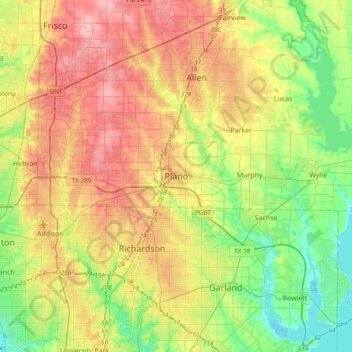
Naam: Topografische kaart Plano, hoogte, reliëf.
Locatie: Plano, Collin County, Texas, 75074, United States (32.85368 -96.85251 33.17368 -96.53251)
Gemiddelde hoogte: 181 m
Minimale hoogte: 131 m
Maximale hoogte: 244 m
At first, Plano's population grew slowly, reaching 1,304 in 1900 and 3,695 in 1960. By 1970, Plano began to feel some of the boom its neighbors had experienced after World War II. A series of public works projects and a change in taxes that removed the farming community from the town helped increase the population. In 1970, the population reached 17,872, and by 1980, it had exploded to 72,000. Sewers, schools, and street development kept pace with this massive increase, largely because of Plano's flat topography, grid layout, and planning initiatives.
Andere topografische kaarten
Klik op een kaart om zijn topografie, zijn hoogte en zijn reliëf te bekijken.
White Rock Creek
United States > Texas > Collin County > Plano
White Rock Creek, Plano, Collin County, Texas, United States
Gemiddelde hoogte: 200 m
Chisholm Trail
United States > Texas > Collin County > Plano
Chisholm Trail, Plano, Collin County, Texas, United States
Gemiddelde hoogte: 210 m