
Topografische kaart Grand Prairie
Interactieve kaart
Klik op de kaart om de hoogte weer te geven.
Over deze kaart
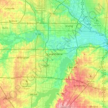
Naam: Topografische kaart Grand Prairie, hoogte, reliëf.
Locatie: Grand Prairie, Dallas County, Texas, 75051, United States (32.58596 -97.15778 32.90596 -96.83778)
Gemiddelde hoogte: 170 m
Minimale hoogte: 120 m
Maximale hoogte: 262 m
Andere topografische kaarten
Klik op een kaart om zijn topografie, zijn hoogte en zijn reliëf te bekijken.
Westchester Valley
United States > Texas > Dallas County > Grand Prairie
Westchester Valley, Grand Prairie, Dallas County, Texas, 75054, United States
Gemiddelde hoogte: 158 m
Joe Pool Lake
United States > Texas > Dallas County > Grand Prairie
Joe Pool Lake, Grand Prairie, Dallas County, Texas, 75054, United States
Gemiddelde hoogte: 186 m
South Westchester Meadows
United States > Texas > Dallas County > Grand Prairie
South Westchester Meadows, Grand Prairie, Dallas County, Texas, 75052, United States
Gemiddelde hoogte: 156 m
Shady Grove
United States > Texas > Dallas County > Grand Prairie
Shady Grove, Grand Prairie, Dallas County, Texas, 75050, United States
Gemiddelde hoogte: 146 m
South Westchester Meadow
United States > Texas > Dallas County > Grand Prairie
South Westchester Meadow, Grand Prairie, Dallas County, Texas, 75052, United States
Gemiddelde hoogte: 158 m
Lakeview
United States > Texas > Dallas County > Grand Prairie
Lakeview, Grand Prairie, Dallas County, Texas, 75051, United States
Gemiddelde hoogte: 149 m