
Topografische kaart Thompson Falls
Interactieve kaart
Klik op de kaart om de hoogte weer te geven.
Thompson Falls
Thompson Falls is located at 47°35′48″N 115°20′37″W / 47.59667°N 115.34361°W / 47.59667; -115.34361 (47.596587, -115.343730) in the Clark Fork Valley at an elevation of 2,419 feet (737 m).
Over deze kaart
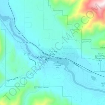
Naam: Topografische kaart Thompson Falls, hoogte, reliëf.
Gemiddelde hoogte: 897 m
Minimale hoogte: 709 m
Maximale hoogte: 2.032 m