
Topografische kaart Egg Harbor
Interactieve kaart
Klik op de kaart om de hoogte weer te geven.
Over deze kaart
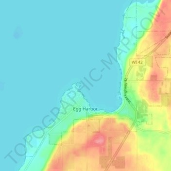
Naam: Topografische kaart Egg Harbor, hoogte, reliëf.
Locatie: Egg Harbor, Door County, Wisconsin, United States (45.03241 -87.32212 45.07375 -87.25151)
Gemiddelde hoogte: 194 m
Minimale hoogte: 173 m
Maximale hoogte: 252 m
Andere topografische kaarten
Klik op een kaart om zijn topografie, zijn hoogte en zijn reliëf te bekijken.
Town of Jacksonport
United States > Wisconsin > Door County
Town of Jacksonport, Door County, Wisconsin, United States
Gemiddelde hoogte: 205 m
Little Sturgeon
United States > Wisconsin > Door County
Little Sturgeon, Town of Gardner, Door County, Wisconsin, United States
Gemiddelde hoogte: 179 m
Brussels
United States > Wisconsin > Door County
Brussels, Town of Brussels, Door County, Wisconsin, 54204, United States
Gemiddelde hoogte: 227 m
Town of Egg Harbor
United States > Wisconsin > Door County
Town of Egg Harbor, Door County, Wisconsin, 54209, United States
Gemiddelde hoogte: 196 m
Fish Creek
United States > Wisconsin > Door County > Fish Creek
Fish Creek, Town of Gibraltar, Door County, Wisconsin, 54212, United States
Gemiddelde hoogte: 189 m
Ellison Bay
United States > Wisconsin > Door County
Ellison Bay, Town of Liberty Grove, Door County, Wisconsin, 54210, United States
Gemiddelde hoogte: 194 m
Sturgeon Bay
United States > Wisconsin > Door County
Sturgeon Bay, Door County, Wisconsin, 54235, United States
Gemiddelde hoogte: 199 m