
Topografische kaart Mountain City
Interactieve kaart
Klik op de kaart om de hoogte weer te geven.
Over deze kaart
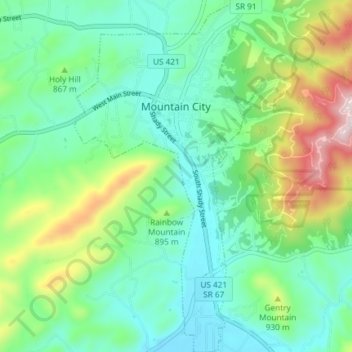
Naam: Topografische kaart Mountain City, hoogte, reliëf.
Gemiddelde hoogte: 827 m
Minimale hoogte: 691 m
Maximale hoogte: 1.179 m
Mountain City is a town in and the county seat of Johnson County, Tennessee, United States. The population was 2,383 at the 2000 census and 2,531 at the 2010 census. It is the northeasternmost county seat in Tennessee. In addition, at an elevation of 2,418 feet (737 m), it has the distinction of being the highest incorporated city in the state.
Andere topografische kaarten
Klik op een kaart om zijn topografie, zijn hoogte en zijn reliëf te bekijken.
Catface Mountain
United States > Tennessee > Johnson County
Catface Mountain, Johnson County, East Tennessee, Tennessee, 28615, United States
Gemiddelde hoogte: 1.032 m
Cross Mountain
United States > Tennessee > Johnson County
Cross Mountain, Johnson County, Tennessee, United States
Gemiddelde hoogte: 1.054 m
Shouns
United States > Tennessee > Johnson County > Mountain City
Shouns, Mountain City, Johnson County, Tennessee, 37638, United States
Gemiddelde hoogte: 786 m
Sugar Creek
United States > Tennessee > Johnson County
Sugar Creek, Johnson County, Tennessee, 37680, United States
Gemiddelde hoogte: 890 m
Butler
United States > Tennessee > Johnson County
Butler, Johnson County, East Tennessee, Tennessee, United States
Gemiddelde hoogte: 671 m
Laurel Bloomery
United States > Tennessee > Johnson County
Laurel Bloomery, Johnson County, East Tennessee, Tennessee, 37680, United States
Gemiddelde hoogte: 806 m
Trade
United States > Tennessee > Johnson County
Trade, Johnson County, East Tennessee, Tennessee, 27691, United States
Gemiddelde hoogte: 1.035 m