
Topografische kaart Grand Isle County
Interactieve kaart
Klik op de kaart om de hoogte weer te geven.
Over deze kaart
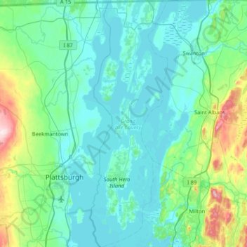
Naam: Topografische kaart Grand Isle County, hoogte, reliëf.
Locatie: Grand Isle County, Vermont, United States (44.56445 -73.39023 45.01342 -73.19128)
Gemiddelde hoogte: 86 m
Minimale hoogte: 26 m
Maximale hoogte: 453 m
According to the U.S. Census Bureau, the county has a total area of 195 square miles (510 km2), of which 82 square miles (210 km2) is land and 113 square miles (290 km2) (58%) is water. It has the highest proportion of water coverage of any county in the state. It is the smallest county in Vermont by area, and the second-smallest by population (only Essex County has fewer people). Four of its five towns (North Hero, South Hero, Grand Isle and Isle La Motte) are situated entirely on islands in Lake Champlain, while Alburgh is on a peninsula (an exclave known as the Alburgh Tongue) extending south into the lake from Quebec. The highest elevation in the county is only 279 feet, on the west side of South Hero. The lake shoreline elevation is generally 99' above sea level.
Andere topografische kaarten
Klik op een kaart om zijn topografie, zijn hoogte en zijn reliëf te bekijken.
Stowe
United States > Vermont > Lamoille County
Stowe, Lamoille County, Vermont, United States
Gemiddelde hoogte: 436 m
Mill Village
United States > Vermont > Orleans County > Craftsbury
Mill Village, Craftsbury, Orleans County, Vermont, 05820, United States
Gemiddelde hoogte: 322 m
Jay
United States > Vermont > Orleans County
Jay, Orleans County, Vermont, 05859, United States
Gemiddelde hoogte: 358 m
Grafton
United States > Vermont > Windham County
Grafton, Windham County, Vermont, United States
Gemiddelde hoogte: 378 m
Tunbridge
United States > Vermont > Orange County
Tunbridge, Orange County, Vermont, 05077, United States
Gemiddelde hoogte: 361 m
Mount Mansfield
United States > Vermont > Chittenden County > Underhill
Mount Mansfield, Underhill, Chittenden County, Vermont, United States
Gemiddelde hoogte: 914 m
Coventry
United States > Vermont > Orleans County
Coventry, Orleans County, Vermont, 05825, United States
Gemiddelde hoogte: 303 m
Fairfax
United States > Vermont > Franklin County
Fairfax, Franklin County, Vermont, 05454, United States
Gemiddelde hoogte: 208 m
Berlin
United States > Vermont > Washington County > Berlin
Berlin, Washington County, Vermont, United States
Gemiddelde hoogte: 320 m
Jeffersonville
United States > Vermont > Lamoille County > Cambridge
Jeffersonville, Cambridge, Lamoille County, Vermont, 05464, United States
Gemiddelde hoogte: 188 m
Topsham Four Corners
United States > Vermont > Orange County > Topsham > Topsham
Topsham Four Corners, Topsham, Orange County, Vermont, 05076, United States
Gemiddelde hoogte: 346 m
Indian Lookout
United States > Vermont > Chittenden County > Williston
Indian Lookout, Williston, Chittenden County, Vermont, United States
Gemiddelde hoogte: 135 m
Mitchell Mountain
United States > Vermont > Essex County > Granby
Mitchell Mountain, Granby, Essex County, Vermont, United States
Gemiddelde hoogte: 613 m
Washington County
Washington County, Vermont, United States
Gemiddelde hoogte: 441 m
Bennington County
Bennington County, Vermont, United States
Gemiddelde hoogte: 429 m
South Burlington
United States > Vermont > Chittenden County
South Burlington, Chittenden County, Vermont, United States
Gemiddelde hoogte: 92 m
West Windsor
United States > Vermont > Windsor County
West Windsor, Windsor County, Vermont, 05037, United States
Gemiddelde hoogte: 366 m
Lyndon
United States > Vermont > Caledonia County
Lyndon, Caledonia County, Vermont, United States
Gemiddelde hoogte: 317 m
Lake Willoughby
United States > Vermont > Orleans County > Westmore
Lake Willoughby, Westmore, Orleans County, Vermont, United States
Gemiddelde hoogte: 500 m
Wallingford
United States > Vermont > Rutland County
Wallingford, Rutland County, Vermont, 05773, United States
Gemiddelde hoogte: 416 m
Cambridge
United States > Vermont > Lamoille County > Cambridge
Cambridge, Lamoille County, Vermont, United States
Gemiddelde hoogte: 315 m
Rutland City
United States > Vermont > Rutland County > Rutland City
Rutland City, Rutland County, Vermont, 05702, United States
Gemiddelde hoogte: 199 m
Jericho
United States > Vermont > Chittenden County > Jericho
Jericho, Chittenden County, Vermont, 05465, United States
Gemiddelde hoogte: 257 m
Woodstock
United States > Vermont > Windsor County > Woodstock
Woodstock, Windsor County, Vermont, United States
Gemiddelde hoogte: 368 m
Windsor
United States > Vermont > Windsor County > Windsor
Windsor, Windsor County, Vermont, 05089, United States
Gemiddelde hoogte: 257 m
Lake Champlain
United States > Vermont > Chittenden County
Lake Champlain, Chittenden County, Vermont, United States
Gemiddelde hoogte: 355 m
Halifax
United States > Vermont > Windham County > Halifax
Halifax, Windham County, Vermont, 05358, United States
Gemiddelde hoogte: 443 m
Shelburne
United States > Vermont > Chittenden County
Shelburne, Chittenden County, Vermont, 05482, United States
Gemiddelde hoogte: 69 m
Jay Peak
United States > Vermont > Westfield
Jay Peak, Westfield, Orleans County, Vermont, United States
Gemiddelde hoogte: 838 m
Union Village
United States > Vermont > Thetford > Union Village
Union Village, Thetford, Orange County, Vermont, 05043, United States
Gemiddelde hoogte: 217 m
Hubbardton
United States > Vermont > Hubbardton
Hubbardton, Rutland County, Vermont, United States
Gemiddelde hoogte: 242 m
Killington
United States > Vermont > Rutland County
Killington, Rutland County, Vermont, 05751, United States
Gemiddelde hoogte: 627 m
Montpelier
United States > Vermont > Washington County
Montpelier, Washington County, Vermont, 05602, United States
Gemiddelde hoogte: 284 m
Sutton River
United States > Vermont > Sutton
Sutton River, Sutton, Caledonia County, Vermont, 05867, United States
Gemiddelde hoogte: 407 m