
Topografische kaart Wermsdorf
Interactieve kaart
Klik op de kaart om de hoogte weer te geven.
Over deze kaart
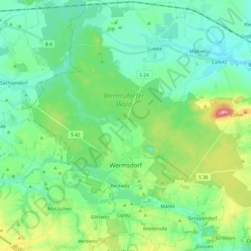
Naam: Topografische kaart Wermsdorf, hoogte, reliëf.
Locatie: Wermsdorf, Nordsachsen, Saxony, 04779, Germany (51.24084 12.86866 51.35502 13.04971)
Gemiddelde hoogte: 176 m
Minimale hoogte: 131 m
Maximale hoogte: 313 m
There are numerous cycling routes of low elevation and trail-ways suitable for walking scattered throughout the nearby Wermsdorf Woods. The nearby lakes are available for bathing, boating and fresh water fishing. Wermsdorf also has a number of hostelries for the enjoyment of traditional German food and drink.