
Topografische kaart St. John's
Interactieve kaart
Klik op de kaart om de hoogte weer te geven.
Over deze kaart
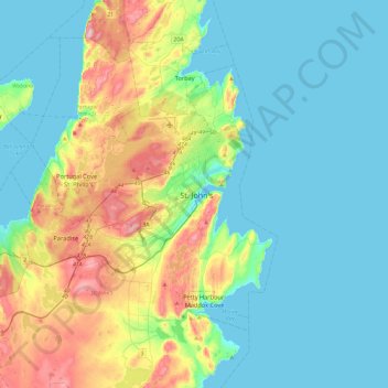
Naam: Topografische kaart St. John's, hoogte, reliëf.
Gemiddelde hoogte: 66 m
Minimale hoogte: -1 m
Maximale hoogte: 272 m
Andere topografische kaarten
Klik op een kaart om zijn topografie, zijn hoogte en zijn reliëf te bekijken.
Airport Road
Canada > Newfoundland and Labrador > St. John's
Airport Road, St. John's, Newfoundland, Newfoundland and Labrador, A1A 4Y3, Canada
Gemiddelde hoogte: 145 m
Blackhead
Canada > Newfoundland and Labrador > St. John's > Blackhead
Blackhead, St. John's, Newfoundland and Labrador, Canada
Gemiddelde hoogte: 48 m