
Topografische kaart Yanqing District
Interactieve kaart
Klik op de kaart om de hoogte weer te geven.
Over deze kaart
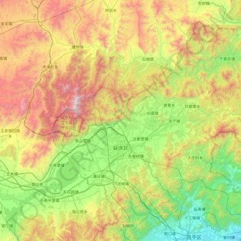
Naam: Topografische kaart Yanqing District, hoogte, reliëf.
Locatie: Yanqing District, Beijing, 102100, China (40.26430 115.72974 40.78988 116.56832)
Gemiddelde hoogte: 806 m
Minimale hoogte: 45 m
Maximale hoogte: 2.199 m
The Yanqing Badaling Great Wall Basin is surrounded by mountains on three sides in the north, south, east, and Guanting Reservoir to the west, namely the Yanhuai Basin. Yanqing is located in the east of the basin, with an average elevation of about 500 meters. Haituo Mountain is the highest peak in the territory, with an elevation of 2241 meters and the second highest peak in Beijing.
Andere topografische kaarten
Klik op een kaart om zijn topografie, zijn hoogte en zijn reliëf te bekijken.
Mutianyu Great Wall
China > Beijing > Huairou District > Lianhuachi
Mutianyu Great Wall, Great Wall of China, Lianhuachi, Huairou District, Beijing, 101405, China
Gemiddelde hoogte: 430 m
Haidian District
China > Beijing > Haidian District
Haidian District, Beijing, China
Gemiddelde hoogte: 70 m
Capital Airport
China > Beijing > Chaoyang District > Capital Airport
Capital Airport, Chaoyang District, Beijing, 100621, China
Gemiddelde hoogte: 30 m
The Eighth Tower of the North Side
China > Beijing > Yanqing District
The Eighth Tower of the North Side, 长城, Yanqing District, Beijing, China
Gemiddelde hoogte: 752 m
Forbidden City
Forbidden City, Beijing, Dongcheng District, Beijing, 100010, China
Gemiddelde hoogte: 50 m
正白旗村
China > Beijing > Haidian District > 正白旗村
正白旗村, Haidian District, Beijing, 100193, China
Gemiddelde hoogte: 48 m
Qinghe
China > Beijing > Haidian District > Qinghe
Qinghe, Haidian District, Beijing, 100085, China
Gemiddelde hoogte: 47 m
Dongcheng District
China > Beijing > Dongcheng District
Beijing, Dongcheng District, Beijing, 100010, China
Gemiddelde hoogte: 497 m
Chaoyang District
China > Beijing > Chaoyang District
Chaoyang District, Beijing, China
Gemiddelde hoogte: 41 m