
Topografische kaart Saint John
Interactieve kaart
Klik op de kaart om de hoogte weer te geven.
Saint John
The topography surrounding Saint John is hilly; a result of the influence of two coastal mountain ranges which run along the Bay of Fundy – the St. Croix Highlands and the Caledonia Highlands. The soil throughout the region is extremely rocky with frequent granite outcrops. The coastal plain hosts numerous freshwater lakes in the eastern, western and northern parts of the city.
Over deze kaart
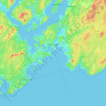
Naam: Topografische kaart Saint John, hoogte, reliëf.
Locatie: Saint John, Saint John County, New Brunswick, Canada (45.13325 -66.24562 45.37693 -65.83886)
Gemiddelde hoogte: 38 m
Minimale hoogte: -7 m
Maximale hoogte: 226 m