
Topografische kaart Scarborough
Interactieve kaart
Klik op de kaart om de hoogte weer te geven.
Over deze kaart
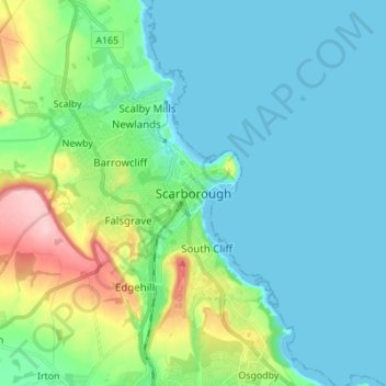
Naam: Topografische kaart Scarborough, hoogte, reliëf.
Gemiddelde hoogte: 39 m
Minimale hoogte: -1 m
Maximale hoogte: 184 m
The climate is temperate with mild summers and cool, windy, winters. The hottest months of the year are July and August, with temperatures reaching an average high of 17 °C and falling to 11 °C at night. The average daytime temperatures in January are 4 °C, falling to 1 °C at night. The station's elevation of 110 m (360 ft) is far above sea level compared to the immediate coastline, where the climate is likely slightly milder year round.
Andere topografische kaarten
Klik op een kaart om zijn topografie, zijn hoogte en zijn reliëf te bekijken.
Rathmell
United Kingdom > England > North Yorkshire
Rathmell, North Yorkshire, England, BD24 0FG, United Kingdom
Gemiddelde hoogte: 172 m
Osgodby
United Kingdom > England > North Yorkshire
Osgodby, North Yorkshire, England, YO11 3PT, United Kingdom
Gemiddelde hoogte: 43 m
Esk Valley
United Kingdom > England > North Yorkshire > Scarborough > Grosmont
Esk Valley, Grosmont, Scarborough, North Yorkshire, England, YO22 5BG, United Kingdom
Gemiddelde hoogte: 127 m
Whitby
United Kingdom > England > North Yorkshire
Whitby, Scarborough, North Yorkshire, England, United Kingdom
Gemiddelde hoogte: 37 m
Selby
United Kingdom > England > North Yorkshire > Selby
Selby, North Yorkshire, England, United Kingdom
Gemiddelde hoogte: 7 m