
Topografische kaart Blackwell Peninsula
Interactieve kaart
Klik op de kaart om de hoogte weer te geven.
Over deze kaart
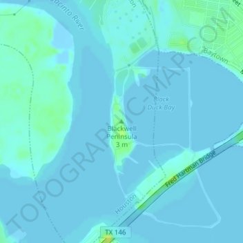
Naam: Topografische kaart Blackwell Peninsula, hoogte, reliëf.
Gemiddelde hoogte: 2 m
Minimale hoogte: -8 m
Maximale hoogte: 20 m
Andere topografische kaarten
Klik op een kaart om zijn topografie, zijn hoogte en zijn reliëf te bekijken.
Tuffly Park
United States > Texas > Harris County > Houston
Tuffly Park, 3200, Greater Fifth Ward, Houston, Harris County, Texas, 77026, United States
Gemiddelde hoogte: 16 m
Kings Point
United States > Texas > Harris County > Houston
Kings Point, Houston, Harris County, Texas, 77345, United States
Gemiddelde hoogte: 20 m
Forest Cove
United States > Texas > Harris County > Houston
Forest Cove, Houston, Harris County, Texas, 77339, United States
Gemiddelde hoogte: 24 m
East Houston
United States > Texas > Harris County > Houston > East Houston
East Houston, Houston, Harris County, Texas, 77028, United States
Gemiddelde hoogte: 15 m
Harrisburg
United States > Texas > Harris County > Houston > Harrisburg
Harrisburg, Houston, Harris County, Texas, 77012, United States
Gemiddelde hoogte: 10 m
Alief
United States > Texas > Harris County > Houston
Alief, Houston, Harris County, Texas, 77099, United States
Gemiddelde hoogte: 25 m
Addicks
United States > Texas > Harris County > Houston > Addicks
Addicks, Houston, Harris County, Texas, 77077, United States
Gemiddelde hoogte: 28 m