
Topografische kaart Waitangi
Interactieve kaart
Klik op de kaart om de hoogte weer te geven.
Over deze kaart
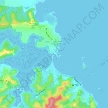
Naam: Topografische kaart Waitangi, hoogte, reliëf.
Gemiddelde hoogte: 15 m
Minimale hoogte: -2 m
Maximale hoogte: 119 m
Andere topografische kaarten
Klik op een kaart om zijn topografie, zijn hoogte en zijn reliëf te bekijken.
Kaeo River
New Zealand > Northland > Far North District > Bay of Islands-Whangaroa Community
Kaeo River, Bay of Islands-Whangaroa Community, Far North District, Northland, New Zealand
Gemiddelde hoogte: 121 m
Kerikeri
New Zealand > Northland > Far North District > Bay of Islands-Whangaroa Community
Kerikeri, Bay of Islands-Whangaroa Community, Far North District, Northland, 0230, New Zealand
Gemiddelde hoogte: 76 m
Rawhiti
New Zealand > Northland > Far North District > Bay of Islands-Whangaroa Community
Rawhiti, Bay of Islands-Whangaroa Community, Far North District, Northland, New Zealand
Gemiddelde hoogte: 45 m
Haruru Falls
New Zealand > Northland > Far North District > Bay of Islands-Whangaroa Community > Haruru
Haruru Falls, Haruru, Bay of Islands-Whangaroa Community, Far North District, Northland, 0204, New Zealand
Gemiddelde hoogte: 34 m
Taupo Bay
New Zealand > Northland > Far North District > Bay of Islands-Whangaroa Community
Taupo Bay, Bay of Islands-Whangaroa Community, Far North District, Northland, 0479, New Zealand
Gemiddelde hoogte: 71 m
Onewhero Bay
New Zealand > Northland > Far North District > Bay of Islands-Whangaroa Community
Onewhero Bay, Bay of Islands-Whangaroa Community, Far North District, Northland, 0204, New Zealand
Gemiddelde hoogte: 18 m
Kaeo
New Zealand > Northland > Far North District > Bay of Islands-Whangaroa Community
Kaeo, Bay of Islands-Whangaroa Community, Far North District, Northland, 0448, New Zealand
Gemiddelde hoogte: 75 m
Paihia
New Zealand > Northland > Far North District > Bay of Islands-Whangaroa Community
Paihia, Bay of Islands-Whangaroa Community, Far North District, Northland, 0252, New Zealand
Gemiddelde hoogte: 27 m