
Topografische kaart Ogden
Interactieve kaart
Klik op de kaart om de hoogte weer te geven.
Over deze kaart
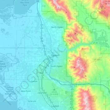
Naam: Topografische kaart Ogden, hoogte, reliëf.
Locatie: Ogden, Weber County, Utah, 84403, United States (41.06300 -112.13384 41.38300 -111.81384)
Gemiddelde hoogte: 1.557 m
Minimale hoogte: 1.279 m
Maximale hoogte: 2.946 m
According to the United States Census Bureau, the city has an area of 26.6 square miles (69.0 km2), all land. Elevations in the city range from about 4,300 to 5,000 feet (1,300 to 1,500 m) above sea level.