
Topografische kaart Marble Canyon
Interactieve kaart
Klik op de kaart om de hoogte weer te geven.
Over deze kaart
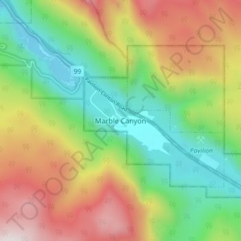
Naam: Topografische kaart Marble Canyon, hoogte, reliëf.
Locatie: Marble Canyon, British Columbia, Canada (50.80169 -121.69281 50.84169 -121.65281)
Gemiddelde hoogte: 1.221 m
Minimale hoogte: 799 m
Maximale hoogte: 1.824 m
Andere topografische kaarten
Klik op een kaart om zijn topografie, zijn hoogte en zijn reliëf te bekijken.
Vancouver Island
The rain shadow effect of the island's mountains, as well as the mountains of Washington's Olympic Peninsula, creates wide variation in precipitation. The west coast is considerably wetter than the east coast. Average annual precipitation ranges from 6,650 mm (262 in) at Hucuktlis Lake on the west coast…
Gemiddelde hoogte: 411 m
Houston
Canada > British Columbia > Regional District of Bulkley-Nechako
The Houston Hikers' Society provides website where trail information, maps, photos and driving directions can be accessed. The Morice Mountain Nordic Ski Club is a volunteer non-profit society. The MMNSC is responsible for all developments and trail grooming as well as maintenance of the facilities, and for…
Gemiddelde hoogte: 728 m
Juan de Fuca Electoral Area
Canada > British Columbia > Capital Regional District
Gemiddelde hoogte: 255 m
Penticton
Canada > British Columbia > Regional District of Okanagan-Similkameen
Penticton is located at the geographical coordinates of 49°29′28″N 119°35′19″W / 49.49111°N 119.58861°W / 49.49111; -119.58861 (Penticton) and covers an area of 42.10 km2 (16.25 sq mi), with a maximum north–south distance of 7 km (4.3 mi) wide between the Okanagan Lake to the north…
Gemiddelde hoogte: 702 m
Garibaldi Provincial Park
Canada > British Columbia > Squamish-Lillooet Regional District
There are over 150 glaciers in the park, including the Garibaldi Névé and Mamquam icefields. The highest peak in Garibaldi Park is Wedge Mountain, at an elevation of 2,891 metres (9,485 ft). It also includes volcanic features such as an andesite tuya known as The Table, a cinder cone known as the Opal Cone,…
Gemiddelde hoogte: 1.318 m
Cortes Island
Canada > British Columbia > Strathcona Regional District > Area C (Cortes Island)
Gemiddelde hoogte: 72 m
Scotch Creek
Canada > British Columbia > Columbia-Shuswap Regional District > Area F (Scotch Creek/Seymour Arm)
Gemiddelde hoogte: 1.125 m
Wasa Lake
Canada > British Columbia > Regional District of East Kootenay > Area E (Saint Mary/Skookumchuck) > Wasa
Gemiddelde hoogte: 793 m
Lillooet Lake
Canada > British Columbia > Squamish-Lillooet Regional District > Area C (Pemberton Valley/Mount Currie/D'Arcy)
Gemiddelde hoogte: 1.177 m
Adams Lake
Canada > British Columbia > Thompson-Nicola Regional District > Area O (Lower North Thompson)
According to one account, the lake is 63 kilometres (39 mi) long and 1.6 to 3.2 kilometres (1.0 to 2.0 mi) wide. The surface elevation is 404 metres (1,325 ft) above sea level. The mean depth of 299 metres (981 ft) and maximum depth of 457 metres (1,499 ft) make the second deepest lake in BC (next to Quesnel…
Gemiddelde hoogte: 1.177 m
Lake O'Hara
Canada > British Columbia > Columbia-Shuswap Regional District > Area A (Kicking Horse/Kinbasket Lake)
Lake O'Hara is a lake at an elevation of 2,020 metres (6,630 ft) in the alpine area of Yoho National Park, in the province of British Columbia, on the western side of the Great Divide with the province of Alberta and Banff National Park to the east. The lake and the valley are accessible through a bus service…
Gemiddelde hoogte: 2.276 m
Radium Hot Springs
Canada > British Columbia > Regional District of East Kootenay
Gemiddelde hoogte: 912 m
Area A (Kicking Horse/Kinbasket Lake)
Canada > British Columbia > Columbia-Shuswap Regional District
Gemiddelde hoogte: 1.846 m
Fairview
Canada > British Columbia > Metro Vancouver Regional District > Vancouver
Gemiddelde hoogte: 31 m
Navvy Jack Point Park
Canada > British Columbia > Metro Vancouver Regional District > West Vancouver
Gemiddelde hoogte: 23 m
Harrison Lake
Canada > British Columbia > Fraser Valley Regional District > Area C (Sasquatch Country)
Gemiddelde hoogte: 815 m
Area B (Lazo North)
Canada > British Columbia > Comox Valley Regional District
Gemiddelde hoogte: 11 m
Mikes Island
Canada > British Columbia > Alberni-Clayoquot Regional District > Area C (Long Beach)
Gemiddelde hoogte: 6 m
Kelowna
Canada > British Columbia > Regional District of Central Okanagan
Kelowna is classified as a humid continental climate or an inland oceanic climate per the Köppen climate classification system due to its coldest month having an average temperature slightly above −3.0 °C (26.6 °F) and below 0 °C (32 °F), with dry, hot, sunny summers and cool, cloudy winters, and four…
Gemiddelde hoogte: 703 m