
Topografische kaart Gurgaon
Interactieve kaart
Klik op de kaart om de hoogte weer te geven.
Over deze kaart
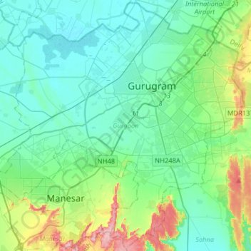
Naam: Topografische kaart Gurgaon, hoogte, reliëf.
Locatie: Gurgaon, Gurugram District, Haryana, India (28.31539 76.86563 28.54090 77.12654)
Gemiddelde hoogte: 237 m
Minimale hoogte: 210 m
Maximale hoogte: 340 m
Andere topografische kaarten
Klik op een kaart om zijn topografie, zijn hoogte en zijn reliëf te bekijken.
Sector 62
India > Haryana > Gurugram District
Sector 62, Gurgaon, Gurugram District, Haryana, India
Gemiddelde hoogte: 235 m
Sector 85
India > Haryana > Gurugram District
Sector 85, Manesar, Gurugram District, Haryana, India
Gemiddelde hoogte: 228 m
Sector 109
India > Haryana > Gurugram District
Sector 109, Gurgaon, Gurugram District, Haryana, India
Gemiddelde hoogte: 214 m
Leisure Valley Park
India > Haryana > Gurugram District
Leisure Valley Park, Sector 29, Gurgaon, Gurugram District, Haryana, India
Gemiddelde hoogte: 235 m