
Topografische kaart Foss
Interactieve kaart
Klik op de kaart om de hoogte weer te geven.
Foss
Foss is located at 35°27′12″N 99°10′15″W / 35.45333°N 99.17083°W / 35.45333; -99.17083 (35.453305, -99.170754), elevation 1,629 feet (497 m). According to the United States Census Bureau, the town has a total area of 0.7 square miles (1.8 km2), all land. Foss State Park is located nearby.
Over deze kaart
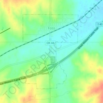
Naam: Topografische kaart Foss, hoogte, reliëf.
Locatie: Foss, Washita County, Oklahoma, United States of America (35.43810 -99.17885 35.45806 -99.16245)
Gemiddelde hoogte: 508 m
Minimale hoogte: 489 m
Maximale hoogte: 538 m