
Doe een donatie
Rust jezelf uit voor je volgende avontuur:
Als Amazon-partner verdient deze site een commissie op in aanmerking komende aankopen, zonder extra kosten voor jou.
Topografische kaart Whitchurch
Klik op de kaart om de hoogte weer te geven.
Doe een donatie
Rust jezelf uit voor je volgende avontuur:
Als Amazon-partner verdient deze site een commissie op in aanmerking komende aankopen, zonder extra kosten voor jou.
Over deze kaart
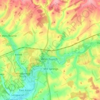
Naam: Topografische kaart Whitchurch, hoogte, reliëf.
Gemiddelde hoogte: 108 m
Minimale hoogte: 52 m
Maximale hoogte: 178 m
Doe een donatie
Rust jezelf uit voor je volgende avontuur:
Als Amazon-partner verdient deze site een commissie op in aanmerking komende aankopen, zonder extra kosten voor jou.
Andere topografische kaarten
Klik op een kaart om zijn topografie, zijn hoogte en zijn reliëf te bekijken.
Basingstoke
United Kingdom > England > Hampshire > Basingstoke and Deane
Situated in a valley through the Hampshire Downs at an average elevation of 88 metres (289 ft) Basingstoke is a major interchange between Reading, Newbury, Andover, Winchester, and Alton, and lies on the natural trade route between the southwest of England and London. The area had been something of an…
Gemiddelde hoogte: 109 m
Morgaston Wood
United Kingdom > England > Hampshire > Basingstoke and Deane > Sherborne St John
Gemiddelde hoogte: 76 m
Sherborne St John
United Kingdom > England > Hampshire > Basingstoke and Deane
Gemiddelde hoogte: 92 m
Doe een donatie
Rust jezelf uit voor je volgende avontuur:
Als Amazon-partner verdient deze site een commissie op in aanmerking komende aankopen, zonder extra kosten voor jou.
Highclere Castle
United Kingdom > England > Hampshire > Basingstoke and Deane
Gemiddelde hoogte: 166 m
Basingstoke
United Kingdom > England > Hampshire > Basingstoke and Deane
Situated in a valley through the Hampshire Downs at an average elevation of 88 metres (289 ft) Basingstoke is a major interchange between Reading, Newbury, Andover, Winchester, and Alton, and lies on the natural trade route between the southwest of England and London. The area had been something of an…
Gemiddelde hoogte: 107 m
Doe een donatie
Rust jezelf uit voor je volgende avontuur:
Als Amazon-partner verdient deze site een commissie op in aanmerking komende aankopen, zonder extra kosten voor jou.
Bramley Corner
United Kingdom > England > Hampshire > Basingstoke and Deane > Bramley
Gemiddelde hoogte: 69 m
Doe een donatie
Rust jezelf uit voor je volgende avontuur:
Als Amazon-partner verdient deze site een commissie op in aanmerking komende aankopen, zonder extra kosten voor jou.
Doe een donatie
Rust jezelf uit voor je volgende avontuur:
Als Amazon-partner verdient deze site een commissie op in aanmerking komende aankopen, zonder extra kosten voor jou.
Pamber Green
United Kingdom > England > Hampshire > Basingstoke and Deane > Tadley
Gemiddelde hoogte: 85 m
Wolverton Townsend
United Kingdom > England > Hampshire > Basingstoke and Deane
Gemiddelde hoogte: 106 m
Cufaude
United Kingdom > England > Hampshire > Basingstoke and Deane > Bramley
Gemiddelde hoogte: 69 m
Doe een donatie
Rust jezelf uit voor je volgende avontuur:
Als Amazon-partner verdient deze site een commissie op in aanmerking komende aankopen, zonder extra kosten voor jou.
River Lyde
United Kingdom > England > Hampshire > Basingstoke and Deane > Up Nately
Gemiddelde hoogte: 78 m
Cole Henley
United Kingdom > England > Hampshire > Basingstoke and Deane > Whitchurch
Gemiddelde hoogte: 118 m
Latchmere Green
United Kingdom > England > Hampshire > Basingstoke and Deane > Little London > Latchmere Green
Gemiddelde hoogte: 73 m
Doe een donatie
Rust jezelf uit voor je volgende avontuur:
Als Amazon-partner verdient deze site een commissie op in aanmerking komende aankopen, zonder extra kosten voor jou.
Heath End
United Kingdom > England > Hampshire > Basingstoke and Deane > East End > Heath End
Gemiddelde hoogte: 144 m
Chilton Candover
United Kingdom > England > Hampshire > Basingstoke and Deane > Chilton Candover
Gemiddelde hoogte: 118 m
Doe een donatie
Rust jezelf uit voor je volgende avontuur:
Als Amazon-partner verdient deze site een commissie op in aanmerking komende aankopen, zonder extra kosten voor jou.
Tufton
United Kingdom > England > Hampshire > Basingstoke and Deane > Hurstbourne Priors
Gemiddelde hoogte: 87 m
Ellisfield Green
United Kingdom > England > Hampshire > Basingstoke and Deane > Ellisfield
Gemiddelde hoogte: 175 m
Doe een donatie
Rust jezelf uit voor je volgende avontuur:
Als Amazon-partner verdient deze site een commissie op in aanmerking komende aankopen, zonder extra kosten voor jou.
Bidden
United Kingdom > England > Hampshire > Basingstoke and Deane > Upton Grey
Gemiddelde hoogte: 107 m
Basingstoke
United Kingdom > England > Hampshire > Basingstoke and Deane
Situated in a valley through the Hampshire Downs at an average elevation of 88 metres (289 ft), Basingstoke is a major interchange between Reading, Newbury, Andover, Winchester and Alton. It lies on the natural trade route between the south-west of England and London. The area had been something of an…
Gemiddelde hoogte: 107 m
Doe een donatie
Rust jezelf uit voor je volgende avontuur:
Als Amazon-partner verdient deze site een commissie op in aanmerking komende aankopen, zonder extra kosten voor jou.
Basingstoke
United Kingdom > England > Hampshire > Basingstoke and Deane
Situated in a valley through the Hampshire Downs at an average elevation of 88 metres (289 ft) Basingstoke is a major interchange between Reading, Newbury, Andover, Winchester, and Alton, and lies on the natural trade route between the southwest of England and London. The area had been something of an…
Gemiddelde hoogte: 107 m
Basingstoke
United Kingdom > England > Hampshire > Basingstoke and Deane
Situated in a valley through the Hampshire Downs at an average elevation of 88 metres (289 ft), Basingstoke is a major interchange between Reading, Newbury, Andover, Winchester and Alton. It lies on the natural trade route between the south-west of England and London. The area had been something of an…
Gemiddelde hoogte: 107 m
Doe een donatie
Rust jezelf uit voor je volgende avontuur:
Als Amazon-partner verdient deze site een commissie op in aanmerking komende aankopen, zonder extra kosten voor jou.