
Topografische kaart Longnan
Interactieve kaart
Klik op de kaart om de hoogte weer te geven.
Over deze kaart
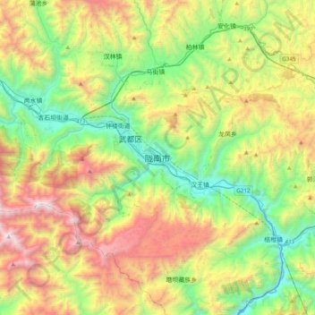
Naam: Topografische kaart Longnan, hoogte, reliëf.
Locatie: Longnan, Wudu District, Longnan City, Gansu, China (33.22712 104.77137 33.54712 105.09137)
Gemiddelde hoogte: 1.854 m
Minimale hoogte: 891 m
Maximale hoogte: 3.569 m
Longnan is in southern Gansu province bordering Shaanxi in the east and Sichuan in the south. It is called Gansu's southern gateway and gateway to the northwest. The major geographic features in Longnan are the Qinba Mountains in the east, the Loess Plateau in the north, and the Tibetan Plateau in the west. It is part of the Central Han basin in the east and the Sichuan basin in the south. Elevations range from 800 to 4,200 m (2,620 to 13,780 ft) above sea level. The three major rivers in Longnan are the Bailong, the Baishui, and the Jialing. Besides these major rivers there are more than 3800 streams and creeks. The annual flow from all of these rivers and streams is more than 28 billion m3. The area of the prefecture is 27,000 square kilometres (10,000 sq mi).