
Doe een donatie
Rust jezelf uit voor je volgende avontuur:
Als Amazon-partner verdient deze site een commissie op in aanmerking komende aankopen, zonder extra kosten voor jou.
Topografische kaart Beacon Mountain
Klik op de kaart om de hoogte weer te geven.
Doe een donatie
Rust jezelf uit voor je volgende avontuur:
Als Amazon-partner verdient deze site een commissie op in aanmerking komende aankopen, zonder extra kosten voor jou.
Over deze kaart
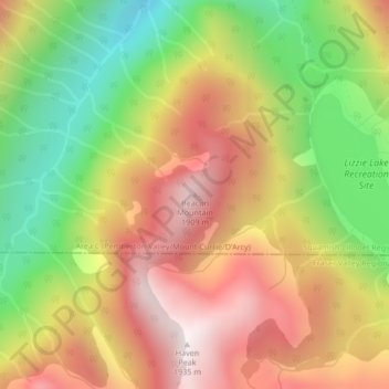
Naam: Topografische kaart Beacon Mountain, hoogte, reliëf.
Gemiddelde hoogte: 1.496 m
Minimale hoogte: 1.028 m
Maximale hoogte: 1.934 m
Doe een donatie
Rust jezelf uit voor je volgende avontuur:
Als Amazon-partner verdient deze site een commissie op in aanmerking komende aankopen, zonder extra kosten voor jou.
Andere topografische kaarten
Klik op een kaart om zijn topografie, zijn hoogte en zijn reliëf te bekijken.
Joffre Lakes Provincial Park
Canada > British Columbia > Squamish-Lillooet Regional District > Area C (Pemberton Valley/Mount Currie/D'Arcy)
Staying on the trail is important for the preservation of the park environment, and for the safety of hikers. Lower Joffre Lake is a short distance away from the parking lot with no elevation gain. The trail to Middle and Upper Joffre lakes however is more challenging due to the greater elevation gain. Hiking…
Gemiddelde hoogte: 1.911 m
Lillooet Lake
Canada > British Columbia > Squamish-Lillooet Regional District > Area C (Pemberton Valley/Mount Currie/D'Arcy)
Gemiddelde hoogte: 1.177 m
Birkenhead Lake Provincial Park
Canada > British Columbia > Squamish-Lillooet Regional District > Area C (Pemberton Valley/Mount Currie/D'Arcy)
Gemiddelde hoogte: 1.558 m
Lillooet Glacier
Canada > British Columbia > Squamish-Lillooet Regional District > Area C (Pemberton Valley/Mount Currie/D'Arcy)
Gemiddelde hoogte: 2.171 m
Doe een donatie
Rust jezelf uit voor je volgende avontuur:
Als Amazon-partner verdient deze site een commissie op in aanmerking komende aankopen, zonder extra kosten voor jou.
Bishop Glacier
Canada > British Columbia > Squamish-Lillooet Regional District > Area C (Pemberton Valley/Mount Currie/D'Arcy)
Gemiddelde hoogte: 1.932 m
Overlord Glacier
Canada > British Columbia > Squamish-Lillooet Regional District > Area C (Pemberton Valley/Mount Currie/D'Arcy)
Gemiddelde hoogte: 2.133 m
Joffre Lakes Provincial Park
Canada > British Columbia > Squamish-Lillooet Regional District > Area C (Pemberton Valley/Mount Currie/D'Arcy)
Staying on the trail is important for the preservation of the park environment, and for the safety of hikers. Lower Joffre Lake is a short distance away from the parking lot with no elevation gain. The trail to Middle and Upper Joffre lakes however is more challenging due to the greater elevation gain. Hiking…
Gemiddelde hoogte: 1.911 m
Needles Glacier
Canada > British Columbia > Squamish-Lillooet Regional District > Area C (Pemberton Valley/Mount Currie/D'Arcy)
Gemiddelde hoogte: 2.126 m
Doe een donatie
Rust jezelf uit voor je volgende avontuur:
Als Amazon-partner verdient deze site een commissie op in aanmerking komende aankopen, zonder extra kosten voor jou.