
Topografische kaart Delicate Arch
Interactieve kaart
Klik op de kaart om de hoogte weer te geven.
Over deze kaart
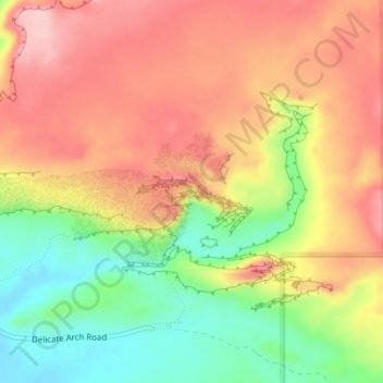
Naam: Topografische kaart Delicate Arch, hoogte, reliëf.
Gemiddelde hoogte: 1.409 m
Minimale hoogte: 1.309 m
Maximale hoogte: 1.490 m
Delicate Arch is one of the main tourist draws in Arches National Park. The parking lot at the Delicate Arch Trailhead, although large, fills up quickly on most days. The trail to Delicate Arch is 3 miles (4.8 kilometer) round trip with an elevation change of 480 feet (146 meters). The trail is well defined for the first 1/2 mile, then does a steep incline over open rock. There is a narrow ledge for the last 200 yards (183 meter) before reaching the arch.
Andere topografische kaarten
Klik op een kaart om zijn topografie, zijn hoogte en zijn reliëf te bekijken.
Moab
United States > Utah > Grand County
Moab, Grand County, Utah, 84532, United States
Gemiddelde hoogte: 1.357 m
Westwater
United States > Utah > Grand County
Westwater, Grand County, Utah, United States
Gemiddelde hoogte: 1.349 m
Cisco
United States > Utah > Grand County
Cisco, Grand County, Utah, 84515, United States
Gemiddelde hoogte: 1.334 m
Rectory
United States > Utah > Grand County
Rectory, Grand County, Utah, United States
Gemiddelde hoogte: 1.527 m
Arches National Park
United States > Utah > Grand County
Arches National Park, Grand County, Utah, United States
Gemiddelde hoogte: 1.476 m
Thompson Springs
United States > Utah > Grand County
Thompson Springs, Grand County, Utah, 84540, United States
Gemiddelde hoogte: 1.583 m
Colorado River
United States > Utah > Grand County > Moab
Colorado River, Moab, Grand County, Utah, United States
Gemiddelde hoogte: 1.668 m
Castle Valley
United States > Utah > Grand County
Castle Valley, Grand County, Utah, United States
Gemiddelde hoogte: 1.610 m
Cottonwood Point
United States > Utah > Grand County
Cottonwood Point, Grand County, Utah, United States
Gemiddelde hoogte: 2.346 m
La Sal Mountains Viewpoint
United States > Utah > Grand County
La Sal Mountains Viewpoint, Main Park Road, Grand County, Utah, 84532-2134, United States
Gemiddelde hoogte: 1.347 m