
Topografische kaart Harchéchamp
Interactieve kaart
Klik op de kaart om de hoogte weer te geven.
Over deze kaart
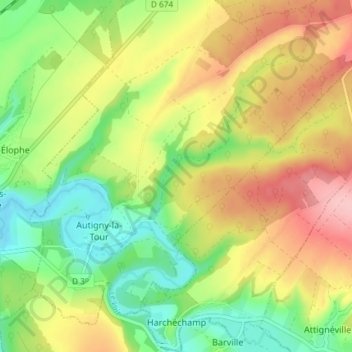
Naam: Topografische kaart Harchéchamp, hoogte, reliëf.
Gemiddelde hoogte: 348 m
Minimale hoogte: 283 m
Maximale hoogte: 425 m
Andere topografische kaarten
Klik op een kaart om zijn topografie, zijn hoogte en zijn reliëf te bekijken.
Blevaincourt
Blevaincourt, Neufchâteau, Vosges, Grand Est, Metropolitan France, 88320, France
Gemiddelde hoogte: 361 m
Le Chêne
France > Grand Est > Vosges > Rupt-sur-Moselle
Le Chêne, Rupt-sur-Moselle, Épinal, Vosges, Grand Est, Metropolitan France, 88360, France
Gemiddelde hoogte: 576 m
Mont-lès-Neufchâteau
Mont-lès-Neufchâteau, Neufchâteau, Vosges, Grand Est, Metropolitan France, 88300, France
Gemiddelde hoogte: 341 m
La Mergerie
France > Grand Est > Vosges > Chef-Haut
La Mergerie, Chef-Haut, Épinal, Vosges, Grand Est, Metropolitan France, 88500, France
Gemiddelde hoogte: 360 m
Le Thillot
Le Thillot, Épinal, Vosges, Grand Est, Metropolitan France, 88160, France
Gemiddelde hoogte: 623 m
Neufchâteau
Neufchâteau, Vosges, Grand Est, Metropolitan France, 88300, France
Gemiddelde hoogte: 334 m
Nayemont
France > Grand Est > Vosges > Ban-de-Sapt
Nayemont, Ban-de-Sapt, Saint-Dié-des-Vosges, Vosges, Grand Est, Metropolitan France, 88210, France
Gemiddelde hoogte: 604 m
La Croix Ferry
France > Grand Est > Vosges > Le Tholy > Le Rain Brice
La Croix Ferry, Le Rain Brice, Le Tholy, Saint-Dié-des-Vosges, Vosges, Grand Est, Metropolitan France, 88530, France
Gemiddelde hoogte: 659 m
Raon-l'Étape
Raon-l'Étape, Saint-Dié-des-Vosges, Vosges, Grand Est, Metropolitan France, 88110, France
Gemiddelde hoogte: 362 m
Rupt-sur-Moselle
France > Grand Est > Vosges > Rupt-sur-Moselle
Rupt-sur-Moselle, Épinal, Vosges, Grand Est, Metropolitan France, 88360, France
Gemiddelde hoogte: 637 m
Plombières-les-Bains
Plombières-les-Bains, Épinal, Vosges, Grand Est, Metropolitan France, 88370, France
Gemiddelde hoogte: 516 m
Colroy-la-Grande
France > Grand Est > Vosges > Provenchères-et-Colroy
Colroy-la-Grande, Provenchères-et-Colroy, Saint-Dié-des-Vosges, Vosges, Grand Est, Metropolitan France, 88490, France
Gemiddelde hoogte: 516 m
Les Poulières
France > Grand Est > Vosges > Les Poulières
Les Poulières, Saint-Dié-des-Vosges, Vosges, Grand Est, Metropolitan France, 88600, France
Gemiddelde hoogte: 510 m
Bettegney-Saint-Brice
France > Grand Est > Vosges > Bettegney-Saint-Brice
Bettegney-Saint-Brice, Épinal, Vosges, Grand Est, Metropolitan France, 88450, France
Gemiddelde hoogte: 349 m
Laveline-devant-Bruyères
France > Grand Est > Vosges > Laveline-devant-Bruyères
Laveline-devant-Bruyères, Épinal, Vosges, Grand Est, Metropolitan France, 88600, France
Gemiddelde hoogte: 492 m
Saint-Maurice-sur-Moselle
France > Grand Est > Vosges > Saint-Maurice-sur-Moselle
Saint-Maurice-sur-Moselle, Épinal, Vosges, Grand Est, Metropolitan France, 88560, France
Gemiddelde hoogte: 815 m
Plainfaing
Plainfaing, Saint-Dié-des-Vosges, Vosges, Grand Est, Metropolitan France, 88230, France
Gemiddelde hoogte: 815 m
Basse-sur-le-Rupt
France > Grand Est > Vosges > Basse-sur-le-Rupt
Basse-sur-le-Rupt, Saint-Dié-des-Vosges, Vosges, Grand Est, Metropolitan France, 88120, France
Gemiddelde hoogte: 677 m
Schlitte Mountain
France > Grand Est > Vosges > La Bresse
Schlitte Mountain, Route de Vologne, La Bresse, Saint-Dié-des-Vosges, Vosges, Grand Est, Metropolitan France, 88250, France
Gemiddelde hoogte: 1.032 m
Ollainville
Ollainville, Neufchâteau, Vosges, Grand Est, Metropolitan France, 88170, France
Gemiddelde hoogte: 354 m
Bellefontaine
Bellefontaine, Épinal, Vosges, Grand Est, Metropolitan France, 88370, France
Gemiddelde hoogte: 544 m