
Topografische kaart Salas pagasts
Interactieve kaart
Klik op de kaart om de hoogte weer te geven.
Over deze kaart
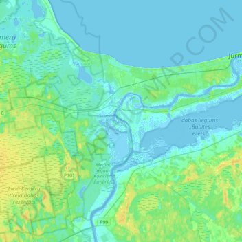
Naam: Topografische kaart Salas pagasts, hoogte, reliëf.
Locatie: Salas pagasts, Mārupes novads, Lijfland, LV-2105, Letland (56.86969 23.49423 56.97059 23.84722)
Gemiddelde hoogte: 5 m
Minimale hoogte: -5 m
Maximale hoogte: 22 m
Andere topografische kaarten
Klik op een kaart om zijn topografie, zijn hoogte en zijn reliëf te bekijken.
Mārupe
Letland > Lijfland > Mārupes novads > Mārupes pagasts
Mārupe, Mārupes pagasts, Mārupe, Mārupes novads, Lijfland, LV-2167, Letland
Gemiddelde hoogte: 12 m
Spuņciems
Letland > Lijfland > Mārupes novads > Salas pagasts
Spuņciems, Salas pagasts, Mārupes novads, Lijfland, LV-2105, Letland
Gemiddelde hoogte: 2 m