
Topografische kaart Indore
Interactieve kaart
Klik op de kaart om de hoogte weer te geven.
Over deze kaart
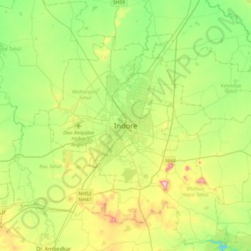
Naam: Topografische kaart Indore, hoogte, reliëf.
Gemiddelde hoogte: 555 m
Minimale hoogte: 445 m
Maximale hoogte: 775 m
Indore /ɪnˈdɔːr/ (listen) is the most populous and the largest city in the Indian state of Madhya Pradesh. It serves as the headquarters of both Indore District and Indore Division. It is also considered as an education hub of the state and has campuses of both the Indian Institute of Technology and the Indian Institute of Management. Located on the southern edge of Malwa Plateau, at an average altitude of 550 meters (1,800 ft) above sea level, it has the highest elevation among major cities of Central India. The city is 190 km (120 mi) west of the state capital of Bhopal. Indore had a census-estimated 2011 population of 1,994,397 (municipal corporation) and 2,170,295 (urban agglomeration). The city is distributed over a land area of just 530 square kilometres (200 sq mi), making Indore the most densely populated major city in the central province. It comes under Tier 2 cities in India.
Andere topografische kaarten
Klik op een kaart om zijn topografie, zijn hoogte en zijn reliëf te bekijken.
Vijay Nagar Udhyaan
India > Madhya Pradesh > Juni Indore Tahsil > Indore
Vijay Nagar Udhyaan, Indore City, Indore, Juni Indore Tahsil, Indore District, Madhya Pradesh, 452001, India
Gemiddelde hoogte: 559 m