
Topografische kaart Aspen
Interactieve kaart
Klik op de kaart om de hoogte weer te geven.
Over deze kaart
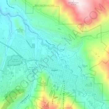
Naam: Topografische kaart Aspen, hoogte, reliëf.
Locatie: Aspen, Pitkin County, Colorado, United States (39.17706 -106.86215 39.21842 -106.80173)
Gemiddelde hoogte: 2.568 m
Minimale hoogte: 2.328 m
Maximale hoogte: 3.162 m
Aspen is a home rule municipality that is the county seat and the most populous municipality of Pitkin County, Colorado, United States. The city population was 7,004 at the 2020 United States Census. Aspen is in a remote area of the Rocky Mountains' Sawatch Range and Elk Mountains, along the Roaring Fork River at an elevation just below 8,000 feet (2,400 m) above sea level on the Western Slope, 11 miles (18 km) west of the Continental Divide. Aspen is now a part of the Glenwood Springs, CO Micropolitan Statistical Area.
Andere topografische kaarten
Klik op een kaart om zijn topografie, zijn hoogte en zijn reliëf te bekijken.
Snowmass Village
United States > Colorado > Pitkin County
Snowmass Village, Pitkin County, Colorado, 81615, United States
Gemiddelde hoogte: 2.675 m
Maroon Bells
United States > Colorado > Pitkin County
Maroon Bells, Pitkin County, Colorado, United States
Gemiddelde hoogte: 3.691 m
Maroon Lake
United States > Colorado > Pitkin County
Maroon Lake, Pitkin County, Colorado, United States
Gemiddelde hoogte: 3.240 m
Snowmass
United States > Colorado > Pitkin County
Snowmass, Pitkin County, Colorado, 81654, United States
Gemiddelde hoogte: 2.322 m
Mount Sopris
United States > Colorado > Pitkin County
Mount Sopris, Pitkin County, Colorado, United States
Gemiddelde hoogte: 3.543 m