
Topografische kaart Oamaru
Interactieve kaart
Klik op de kaart om de hoogte weer te geven.
Over deze kaart
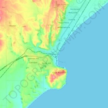
Naam: Topografische kaart Oamaru, hoogte, reliëf.
Locatie: Oamaru, Waitaki District, Otago, 9444, New Zealand (-45.13977 170.92842 -45.05977 171.00842)
Gemiddelde hoogte: 34 m
Minimale hoogte: 0 m
Maximale hoogte: 140 m
Andere topografische kaarten
Klik op een kaart om zijn topografie, zijn hoogte en zijn reliëf te bekijken.
Tokarahi
New Zealand > Otago > Waitaki District
Tokarahi, Waitaki District, Otago, New Zealand
Gemiddelde hoogte: 274 m
Pukeuri
New Zealand > Otago > Waitaki District
Pukeuri, Waitaki District, Otago, New Zealand
Gemiddelde hoogte: 44 m
Moonlight
New Zealand > Otago > Waitaki District
Moonlight, Waitaki District, Otago, New Zealand
Gemiddelde hoogte: 478 m
Waitaki Bridge
New Zealand > Otago > Waitaki District
Waitaki Bridge, Waitaki District, Otago, 7980, New Zealand
Gemiddelde hoogte: 19 m
Macraes
New Zealand > Otago > Waitaki District > Macraes
Macraes, Waitaki District, Otago, New Zealand
Gemiddelde hoogte: 503 m
Taranui
New Zealand > Otago > Waitaki District > Kakanui > Taranui
Taranui, Kakanui, Waitaki District, Otago, New Zealand
Gemiddelde hoogte: 15 m
Waynes
New Zealand > Otago > Waitaki District > Waynes
Waynes, Waitaki District, Otago, New Zealand
Gemiddelde hoogte: 121 m
Moeraki
New Zealand > Otago > Waitaki District
Moeraki, Waitaki District, Otago, 9482, New Zealand
Gemiddelde hoogte: 42 m