
Doe een donatie
Rust jezelf uit voor je volgende avontuur:
Als Amazon-partner verdient deze site een commissie op in aanmerking komende aankopen, zonder extra kosten voor jou.
Topografische kaart Berkshire
Klik op de kaart om de hoogte weer te geven.
Doe een donatie
Rust jezelf uit voor je volgende avontuur:
Als Amazon-partner verdient deze site een commissie op in aanmerking komende aankopen, zonder extra kosten voor jou.
Berkshire
All of the county is drained by the Thames. Berkshire divides into two topological (and associated geological) sections: east and west of Reading. North-east Berkshire has the low calciferous (limestone) m-shaped bends of the Thames south of which is a broader, clayey, gravelly former watery plain or belt from Earley to Windsor and beyond, south, are parcels and belts of uneroded higher sands, flints, shingles and lightly acid soil and in the north of the Bagshot Formation, north of Surrey and Hampshire. Swinley Forest (also known as Bracknell Forest), Windsor Great Park, Crowthorne and Stratfield Saye Woods have many pine, silver birch, and other lightly acid-soil trees. East of the grassy and wooded bends a large minority of East Berkshire's land mirrors the clay belt, being of low elevation and on the left (north) bank of the Thames: Slough, Eton, Eton Wick, Wraysbury, Horton, and Datchet. In the heart of the county Reading's northern suburb Caversham is also on that bank, but rises steeply into the Chiltern Hills.
Doe een donatie
Rust jezelf uit voor je volgende avontuur:
Als Amazon-partner verdient deze site een commissie op in aanmerking komende aankopen, zonder extra kosten voor jou.
Over deze kaart
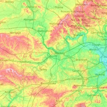
Naam: Topografische kaart Berkshire, hoogte, reliëf.
Locatie: Berkshire, Reading, England, United Kingdom (51.32896 -1.58809 51.57783 -0.49004)
Gemiddelde hoogte: 100 m
Minimale hoogte: 11 m
Maximale hoogte: 294 m
Doe een donatie
Rust jezelf uit voor je volgende avontuur:
Als Amazon-partner verdient deze site een commissie op in aanmerking komende aankopen, zonder extra kosten voor jou.
Andere topografische kaarten
Klik op een kaart om zijn topografie, zijn hoogte en zijn reliëf te bekijken.
Reading
United Kingdom > England > Reading
Mary Russell Mitford lived in Reading for a number of years and then spent the rest of her life just outside the town at Three Mile Cross and Swallowfield. The fictional Belford Regis of her eponymous novel, first published in 1835, is largely based on Reading. Described with topographical accuracy, it is…
Gemiddelde hoogte: 56 m
Doe een donatie
Rust jezelf uit voor je volgende avontuur:
Als Amazon-partner verdient deze site een commissie op in aanmerking komende aankopen, zonder extra kosten voor jou.
Reading
United Kingdom > England > Reading
Jane Austen attended Reading Ladies Boarding School, based in the Abbey Gateway, in 1784–1786. Mary Russell Mitford lived in Reading for a number of years and then spent the rest of her life just outside the town at Three Mile Cross and Swallowfield. The fictional Belford Regis of her eponymous novel, first…
Gemiddelde hoogte: 56 m