
Topografische kaart Aigre
Interactieve kaart
Klik op de kaart om de hoogte weer te geven.
Aigre
The south of the commune is a plateau. The Aume Valley is near the north-eastern border near the town. The highest point of the commune is at an altitude of 129m located on the south-eastern boundary (IGN marker). The lowest point is 62m located on the eastern boundary along the Aume at Aizef. The town is built in an old loop of the river and is 65m above sea level.
Over deze kaart
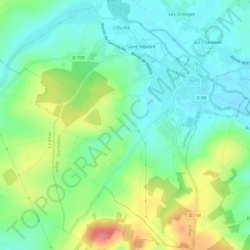
Naam: Topografische kaart Aigre, hoogte, reliëf.
Gemiddelde hoogte: 90 m
Minimale hoogte: 62 m
Maximale hoogte: 146 m