
Topografische kaart Wieżyca
Interactieve kaart
Klik op de kaart om de hoogte weer te geven.
Over deze kaart
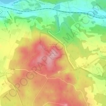
Naam: Topografische kaart Wieżyca, hoogte, reliëf.
Gemiddelde hoogte: 247 m
Minimale hoogte: 162 m
Maximale hoogte: 325 m
Wieżyca (Kashubian Wieżëca, German Turmberg) is a hill located in northern Poland, in the historical region of Kashubia, some 40 kilometers southwest of Gdańsk. With elevation of 329 metres above sea level, it is the highest peak of central and northern Poland. Its top is covered by a forest, and the hill was the object of pagan cult of ancient Slavs. Wieżyca is a popular tourist area, with a ski lift and a ski slope.