
Topografische kaart Pico de Mulhacén
Interactieve kaart
Klik op de kaart om de hoogte weer te geven.
Over deze kaart
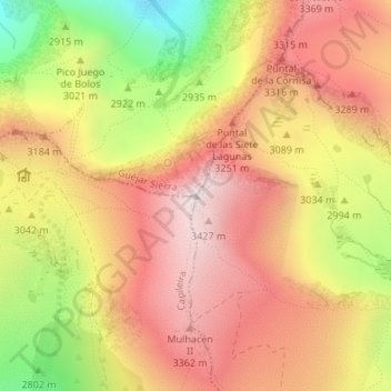
Naam: Topografische kaart Pico de Mulhacén, hoogte, reliëf.
Gemiddelde hoogte: 3.070 m
Minimale hoogte: 2.489 m
Maximale hoogte: 3.473 m
Mulhacén ([mulaˈθen]), with an elevation of 3,482 metres (11,424 ft), is the highest mountain in peninsular Spain and in all of the Iberian Peninsula. It is part of the Sierra Nevada range in the Penibaetic System. It is named after Abu'l-Hasan Ali, known as Muley Hacén in Spanish, the penultimate Muslim ruler of Granada in the 15th century who, according to legend, was buried on the summit of the mountain.