
Topografische kaart Escondido
Interactieve kaart
Klik op de kaart om de hoogte weer te geven.
Over deze kaart
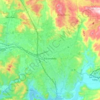
Naam: Topografische kaart Escondido, hoogte, reliëf.
Locatie: Escondido, San Diego County, California, United States (33.05784 -117.14610 33.21161 -116.99386)
Gemiddelde hoogte: 273 m
Minimale hoogte: 87 m
Maximale hoogte: 703 m
Escondido has a borderline semi-arid climate (Köppen: Bsh) and hot-summer Mediterranean climate (Köppen: Csa) with hot summers and cool wet winters. Owing to its inland setting it is considerably warmer than coastal cities like San Diego, Carlsbad or Oceanside during the summertime, and cooler in the winter. Yearly precipitation averages around 15 inches (380 mm) and can vary considerably from year to year. Rainfall totals are higher in the hills to the north and east, with 20-24 inches falling in most areas above 2,000 feet elevation, and over 30 inches on Palomar Mountain, 15 miles east. More than 80% of all precipitation takes place from November through March. Snow is virtually unheard of, though occasionally winter and springtime thunderstorms will drop small hail. The climate is mild enough to allow widespread cultivation of avocados and oranges. Escondido is located in a plant hardiness zone 10a. The hottest temperature recorded in Escondido was 115 °F on September 6, 2020. The coldest temperature recorded in Escondido was 13 °F on January 2, 1901, and January 7, 1913.[16]
Andere topografische kaarten
Klik op een kaart om zijn topografie, zijn hoogte en zijn reliëf te bekijken.
Lemon Grove
United States > California > San Diego County
Lemon Grove, San Diego County, California, 91945, United States
Gemiddelde hoogte: 129 m
Woodson Mountain
United States > California > San Diego County
Woodson Mountain, San Diego County, California, United States
Gemiddelde hoogte: 560 m
Ipai Waaypuk
United States > California > San Diego County > Poway
Ipai Waaypuk, Poway, San Diego County, California, 92064, United States
Gemiddelde hoogte: 186 m
El Cajon
United States > California > San Diego County
El Cajon, San Diego County, California, United States
Gemiddelde hoogte: 178 m
Del Mar
United States > California > San Diego County
Del Mar, San Diego County, California, United States
Gemiddelde hoogte: 24 m
San Marcos
United States > California > San Diego County
San Marcos, San Diego County, California, United States
Gemiddelde hoogte: 219 m
Poway
United States > California > San Diego County
Poway, San Diego County, CAL Fire Southern Region, California, 92064, United States
Gemiddelde hoogte: 275 m
Solana Beach
United States > California > San Diego County
Solana Beach, San Diego County, CAL Fire Southern Region, California, 92075, United States
Gemiddelde hoogte: 21 m
Bonita
United States > California > San Diego County
Bonita, San Diego County, CAL Fire Southern Region, California, 91902, United States
Gemiddelde hoogte: 95 m
Sunshine Mountain
United States > California > San Diego County
Sunshine Mountain, San Diego County, California, United States
Gemiddelde hoogte: 811 m
San Diego
United States > California > San Diego County
San Diego, San Diego County, CAL Fire Southern Region, California, United States
Gemiddelde hoogte: 125 m
Cree
United States > California > San Diego County > Poway > Ipai Waaypuk
Cree, Ipai Waaypuk, Poway, San Diego County, California, 92064, United States
Gemiddelde hoogte: 179 m
Oceanside
United States > California > San Diego County > Oceanside
Oceanside, San Diego County, California, United States
Gemiddelde hoogte: 33 m
Chula Vista
United States > California > San Diego County > Chula Vista
Chula Vista, San Diego County, California, 91912, United States
Gemiddelde hoogte: 81 m
Carlsbad
United States > California > San Diego County
Carlsbad, San Diego County, CAL Fire Southern Region, California, United States
Gemiddelde hoogte: 24 m
Chula Vista
United States > California > San Diego County
Chula Vista, San Diego County, California, United States
Gemiddelde hoogte: 42 m