
Topografische kaart Candlewood Isle
Interactieve kaart
Klik op de kaart om de hoogte weer te geven.
Over deze kaart
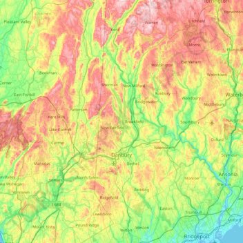
Naam: Topografische kaart Candlewood Isle, hoogte, reliëf.
Gemiddelde hoogte: 176 m
Minimale hoogte: -3 m
Maximale hoogte: 462 m
Andere topografische kaarten
Klik op een kaart om zijn topografie, zijn hoogte en zijn reliëf te bekijken.
Taylor Corners
United States > Connecticut > Western Connecticut Planning Region > New Fairfield
Taylor Corners, New Fairfield, Western Connecticut Planning Region, Connecticut, 06812, United States
Gemiddelde hoogte: 226 m
Knollcrest
United States > Connecticut > Western Connecticut Planning Region > New Fairfield
Knollcrest, New Fairfield, Western Connecticut Planning Region, Connecticut, 06812, United States
Gemiddelde hoogte: 185 m
Bigelow Corners
United States > Connecticut > Western Connecticut Planning Region > New Fairfield
Bigelow Corners, New Fairfield, Western Connecticut Planning Region, Connecticut, 06812, United States
Gemiddelde hoogte: 222 m
Candlewood Knolls
United States > Connecticut > Western Connecticut Planning Region > New Fairfield
Candlewood Knolls, New Fairfield, Western Connecticut Planning Region, Connecticut, 06812, United States
Gemiddelde hoogte: 176 m
Bogus Hill
United States > Connecticut > Western Connecticut Planning Region > New Fairfield
Bogus Hill, New Fairfield, Western Connecticut Planning Region, Connecticut, 06812, United States
Gemiddelde hoogte: 161 m
Ball Pond
United States > Connecticut > Western Connecticut Planning Region > New Fairfield
Ball Pond, New Fairfield, Western Connecticut Planning Region, Connecticut, 06812, United States
Gemiddelde hoogte: 222 m