
Topografische kaart Odell
Interactieve kaart
Klik op de kaart om de hoogte weer te geven.
Over deze kaart
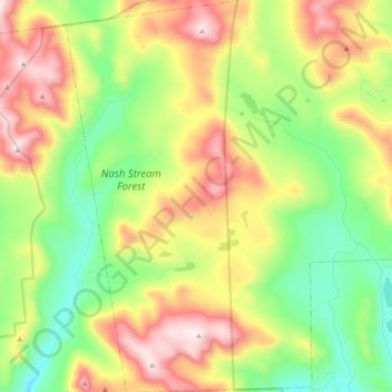
Naam: Topografische kaart Odell, hoogte, reliëf.
Locatie: Odell, Coös County, New Hampshire, United States (44.65996 -71.44437 44.79573 -71.32428)
Gemiddelde hoogte: 673 m
Minimale hoogte: 368 m
Maximale hoogte: 1.114 m
A substantial portion of the state-owned Nash Stream Forest lies within the township. There are three mountains, each having elevations above 3,000 feet (910 m): Muise Mountain, Whitcomb Mountain and Long Mountain, whose two summits are the two highest points in Odell, at 3,661 feet (1,116 m) above sea level each. There are only a few rough roads and no highways here.