
Topografische kaart Kovar
Interactieve kaart
Klik op de kaart om de hoogte weer te geven.
Over deze kaart
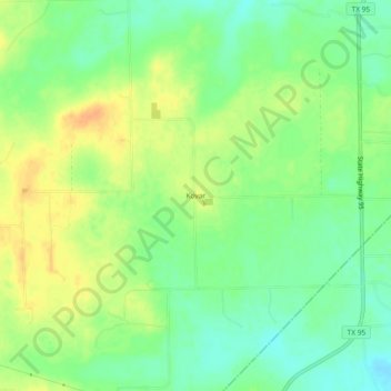
Naam: Topografische kaart Kovar, hoogte, reliëf.
Locatie: Kovar, Bastrop County, Texas, United States (29.88189 -97.23388 29.92189 -97.19388)
Gemiddelde hoogte: 134 m
Minimale hoogte: 117 m
Maximale hoogte: 151 m
Andere topografische kaarten
Klik op een kaart om zijn topografie, zijn hoogte en zijn reliëf te bekijken.
Bastrop
United States > Texas > Bastrop County
Bastrop, Bastrop County, Texas, 78602, United States
Gemiddelde hoogte: 129 m
McDade
United States > Texas > Bastrop County
McDade, Bastrop County, Texas, 78650, United States
Gemiddelde hoogte: 162 m
Bateman
United States > Texas > Bastrop County
Bateman, Bastrop County, Texas, 78662, United States
Gemiddelde hoogte: 146 m
Togo
United States > Texas > Bastrop County
Togo, Bastrop County, Texas, United States
Gemiddelde hoogte: 143 m
Rockne
United States > Texas > Bastrop County
Rockne, Bastrop County, Texas, 78662, United States
Gemiddelde hoogte: 139 m
Circle D-KC Estates
United States > Texas > Bastrop County
Circle D-KC Estates, Bastrop County, Texas, United States
Gemiddelde hoogte: 159 m
Rosanky
United States > Texas > Bastrop County
Rosanky, Bastrop County, Texas, United States
Gemiddelde hoogte: 153 m
Colorado River
United States > Texas > Bastrop County > Bastrop
Colorado River, Bastrop, Bastrop County, Texas, 78602, United States
Gemiddelde hoogte: 125 m
Smithville
United States > Texas > Bastrop County > Smithville > Smithville
Smithville, Bastrop County, Texas, 78957, United States
Gemiddelde hoogte: 107 m
Smithville
United States > Texas > Bastrop County
Smithville, Bastrop County, Texas, 78957, United States
Gemiddelde hoogte: 100 m
Elgin
United States > Texas > Bastrop County
Elgin, Bastrop County, Texas, United States
Gemiddelde hoogte: 167 m
Cedar Creek
United States > Texas > Bastrop County > Cedar Creek
Cedar Creek, Bastrop County, Texas, 78612, United States
Gemiddelde hoogte: 137 m