
Topografische kaart Champéry
Interactieve kaart
Klik op de kaart om de hoogte weer te geven.
Over deze kaart
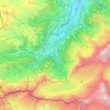
Naam: Topografische kaart Champéry, hoogte, reliëf.
Locatie: Champéry, Monthey, Wallis, 1874, Schweiz (46.12927 6.79029 46.19007 6.91014)
Gemiddelde hoogte: 1.883 m
Minimale hoogte: 820 m
Maximale hoogte: 3.251 m
Andere topografische kaarten
Klik op een kaart om zijn topografie, zijn hoogte en zijn reliëf te bekijken.
Les Cornettes de Bise
Schweiz > Wallis > Monthey > Vouvry
Les Cornettes de Bise, Vouvry, Monthey, Wallis, 1896, Schweiz
Gemiddelde hoogte: 1.904 m