
Topografische kaart River Kennet
Interactieve kaart
Klik op de kaart om de hoogte weer te geven.
Over deze kaart
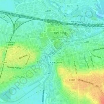
Naam: Topografische kaart River Kennet, hoogte, reliëf.
Gemiddelde hoogte: 47 m
Minimale hoogte: 32 m
Maximale hoogte: 78 m
Andere topografische kaarten
Klik op een kaart om zijn topografie, zijn hoogte en zijn reliëf te bekijken.
Old Mills
United Kingdom > England > Bath and North East Somerset > Paulton
Old Mills, Paulton, Bath and North East Somerset, West of England, England, BS39 7SR, United Kingdom
Gemiddelde hoogte: 126 m
Clandown
United Kingdom > England > Bath and North East Somerset > Radstock
Clandown, Radstock, Bath and North East Somerset, West of England, England, BA3 3DW, United Kingdom
Gemiddelde hoogte: 118 m
Peasedown St. John
United Kingdom > England > Bath and North East Somerset
Peasedown St. John, Bath and North East Somerset, West of England, England, United Kingdom
Gemiddelde hoogte: 125 m
Batheaston
United Kingdom > England > Bath and North East Somerset > Batheaston
Batheaston, Bath and North East Somerset, West of England, England, United Kingdom
Gemiddelde hoogte: 114 m
Bath
United Kingdom > England > Bath and North East Somerset
Bath, Bath and North East Somerset, West of England, England, United Kingdom
Gemiddelde hoogte: 100 m
Chew Magna
United Kingdom > England > Bath and North East Somerset > Chew Magna
Chew Magna, Bath and North East Somerset, West of England, England, United Kingdom
Gemiddelde hoogte: 90 m
Monkton Combe
United Kingdom > England > Bath and North East Somerset
Monkton Combe, Bath and North East Somerset, West of England, England, United Kingdom
Gemiddelde hoogte: 102 m
Bishop Sutton
United Kingdom > England > Bath and North East Somerset
Bishop Sutton, Bath and North East Somerset, West of England, England, BS39 5EH, United Kingdom
Gemiddelde hoogte: 86 m