
Topografische kaart Mascot
Interactieve kaart
Klik op de kaart om de hoogte weer te geven.
Over deze kaart
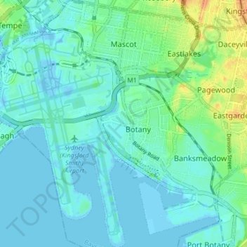
Naam: Topografische kaart Mascot, hoogte, reliëf.
Gemiddelde hoogte: 8 m
Minimale hoogte: -7 m
Maximale hoogte: 34 m
Andere topografische kaarten
Klik op een kaart om zijn topografie, zijn hoogte en zijn reliëf te bekijken.
Turrella
Australia > New South Wales > Bayside Council > Sydney
Turrella, St George, Sydney, Bayside Council, New South Wales, 2205, Australia
Gemiddelde hoogte: 20 m
Botany Bay
Australia > New South Wales > Bayside Council > Sydney
Botany Bay, Sutherland Shire, Sydney, Sutherland Shire Council, Bayside Council, New South Wales, Australia
Gemiddelde hoogte: 8 m
Rockdale
Australia > New South Wales > Bayside Council > Sydney
Rockdale, St George, Sydney, Bayside Council, New South Wales, 2216, Australia
Gemiddelde hoogte: 20 m